

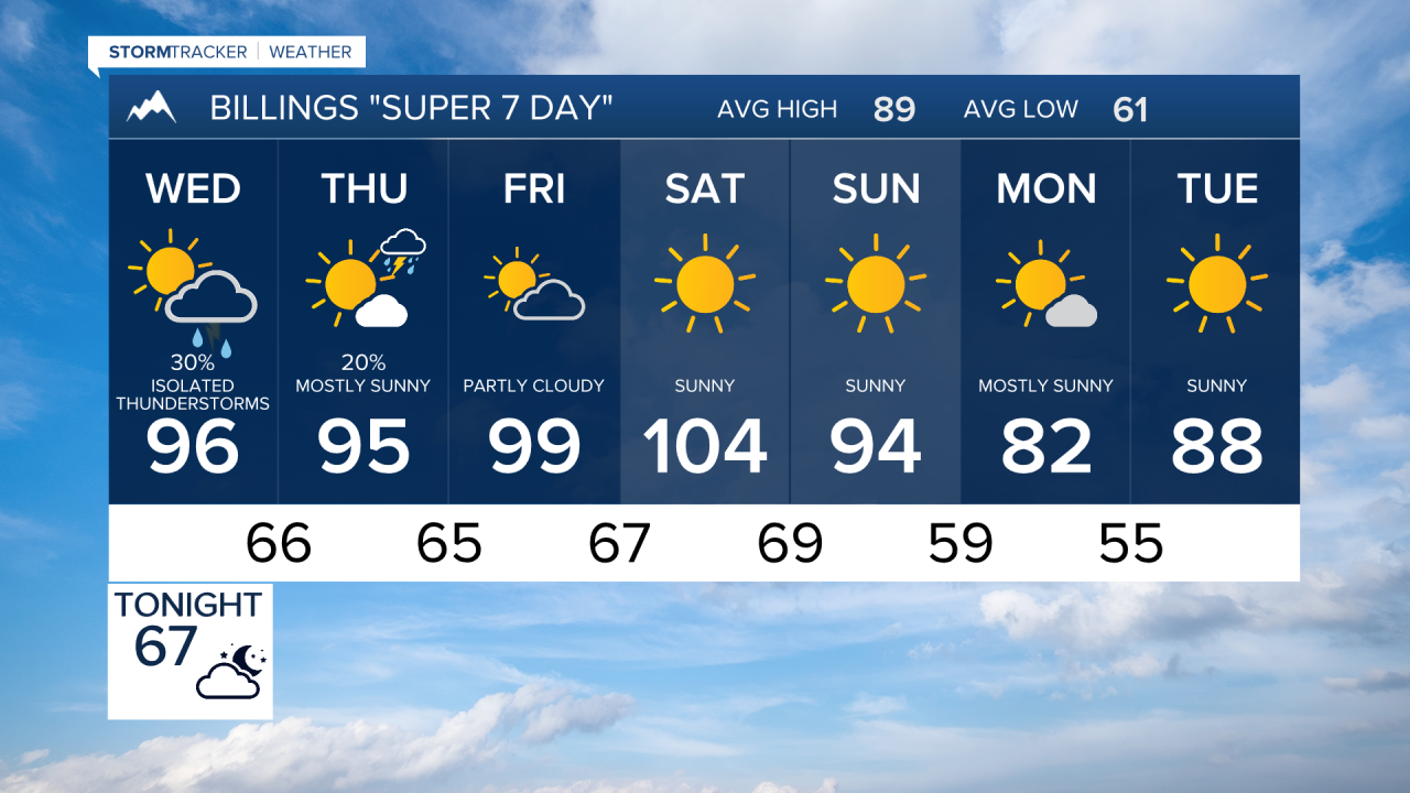


BILLINGS — Hot, smoky, and mostly dry weather will continue across south-central and southeast Montana through the week. Daily afternoon and evening thunderstorm chances persist, with the greatest threat for strong storms arriving Wednesday across southeast Montana where a few storms could produce wind gusts up to 65 mph.
Smoke from Pacific Northwest wildfires will continue to impact visibility and air quality at times. Temperatures remain hot through the weekend before a potential cooling trend develops early next week.
TUESDAY NIGHT
Isolated to scattered showers and thunderstorms will continue into the evening, developing mainly over the southwest mountains before drifting northeast across central portions of the area. A few stronger storms may produce wind gusts between 45 and 60 mph, especially from the foothills into Yellowstone County. Activity will gradually weaken overnight. Smoke will continue to create periods of reduced visibility and air quality.
WEDNESDAY
Hot temperatures and monsoonal moisture remain in place. Isolated to scattered afternoon and evening thunderstorms are expected, with the strongest storms focused across southeast Montana and areas east of Billings. A few storms may produce wind gusts up to 65 mph, brief heavy rainfall, and localized hazardous conditions. Smoke will remain widespread, causing periodic impacts to visibility and air quality.
THURSDAY
Hot and conditions continue with high in the 90s to low 100s.. Most locations will stay dry, but any storms that develop could bring gusty winds and brief downpours. Smoke is expected to linger across the region.
FRIDAY
The weather pattern changes very little, with above-normal temperatures, smoky skies, and isolated to scattered afternoon and evening thunderstorms. Storm coverage will remain limited, but locally gusty winds are possible with stronger cells.
SATURDAY
Hot temperatures persist with many of the hottest temperatures of the week. Highs in the upper 90s to triple digits. A low chance of afternoon and evening thunderstorms continues, while smoke remains a concern for air quality and visibility. Most locations will experience dry conditions.
SUNDAY
Forecast models indicate the upper-level ridge may begin to weaken. Temperatures should remain warm, but increasing winds and an approaching frontal system could elevate fire weather concerns. Isolated thunderstorms remain possible.
MONDAY
A cooler air mass may spread into the region as the ridge breaks down. Temperatures are expected to trend lower than previous days, though isolated showers and thunderstorms could still occur. Highs in the 80s and 90s. Breezier conditions may persist behind the frontal passage.
