

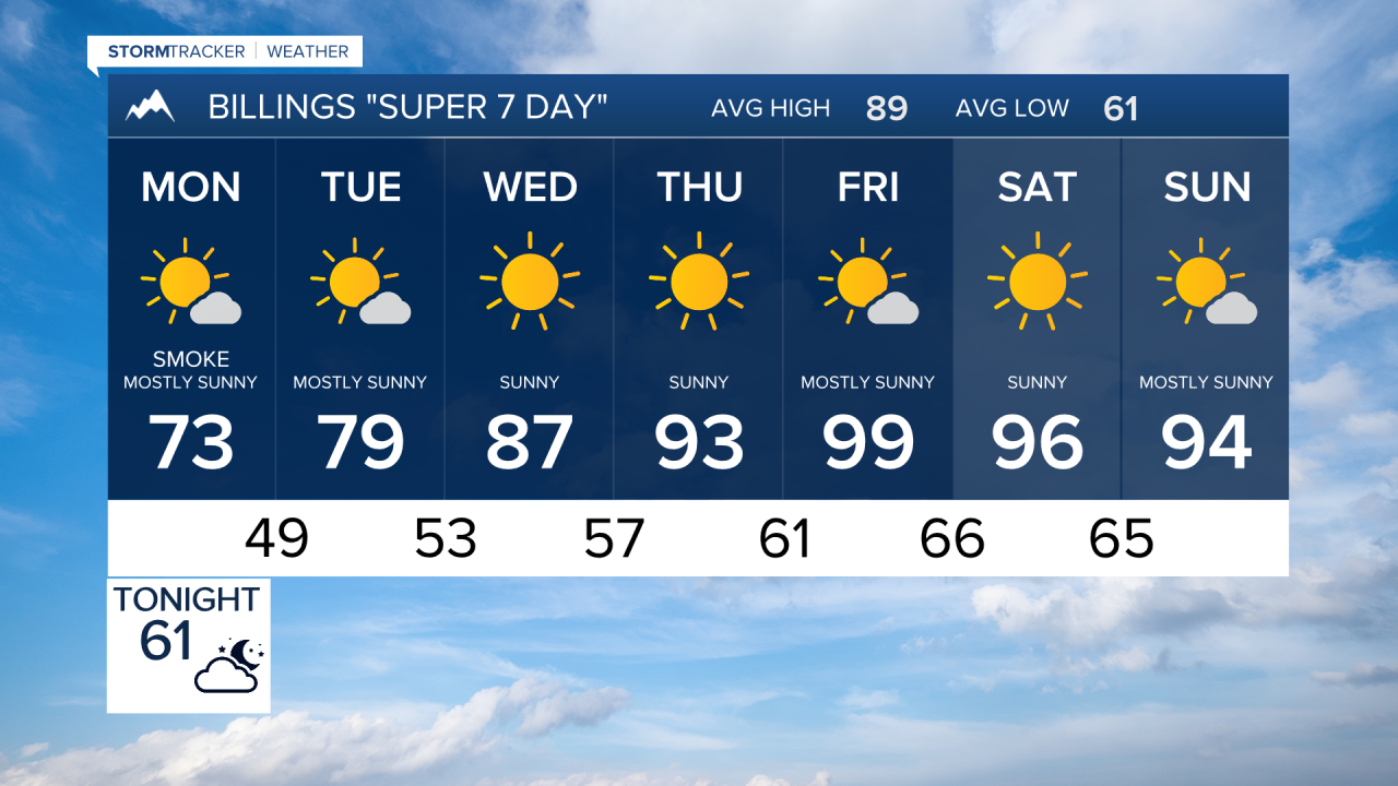


BILLINGS — Hot, dry, and windy conditions will keep fire danger elevated across much of Montana through Sunday evening, with critical fire weather conditions continuing into Monday over far eastern portions of the state. A strong cold front will bring cooler temperatures for the first half of the week, while wildfire smoke impacts air quality at times. Warmth quickly returns late week, with some eastern Montana locations potentially nearing 100 degrees again by Friday.
SUNDAY EVENING
Wildfire smoke moving through Montana and Wyoming will lead to periods of reduced air quality. A slight chance of an isolated shower or thunderstorm exists over parts of central Montana this evening, but most areas remain dry.
MONDAY
A stronger cold front sweeps across the state overnight into Monday, bringing cooler temperatures, higher humidity, and gusty northwest to northeast winds. Most locations will see highs ranging from the upper 60s to lower 80s. While fire danger decreases in many areas, elevated fire weather conditions persist, with critical fire weather concerns lingering across far eastern Montana.
TUESDAY
Cooler temperatures continue with generally dry weather statewide. Overnight lows drop into the 40s and 50s across lower elevations, while mountain locations above 7,000 feet may see temperatures fall into the 30s. Light winds and improved humidity help limit fire weather concerns. Highs will be in the 70 and 80s.
WEDNESDAY
A warming trend begins as high pressure gradually rebuilds across the Northern Rockies. Dry conditions dominate, with temperatures climbing back above seasonal averages. Fire danger may begin increasing again as warmer and drier conditions return. More highs in the 80s.
THURSDAY
Warm and mainly dry weather continues statewide. Afternoon temperatures rise well into the 80s and lower 90s, with little in the way of precipitation expected. Smoke could remain an occasional concern depending on wildfire activity and transport patterns.
FRIDAY
Friday currently appears to be the warmest day of the week. High temperatures are expected to reach the 90s across much of Montana, with eastern portions of the state having a moderate chance of reaching or exceeding 100 degrees. Dry conditions continue, leading to increasing fire weather concerns.
SATURDAY
Warm temperatures persist into the weekend, although a cold front may begin to approach and slightly cool conditions. Most areas remain dry, but forecasters are monitoring signs that monsoonal moisture could begin returning late in the weekend and into next week, potentially bringing increasing chances for showers and thunderstorms.
