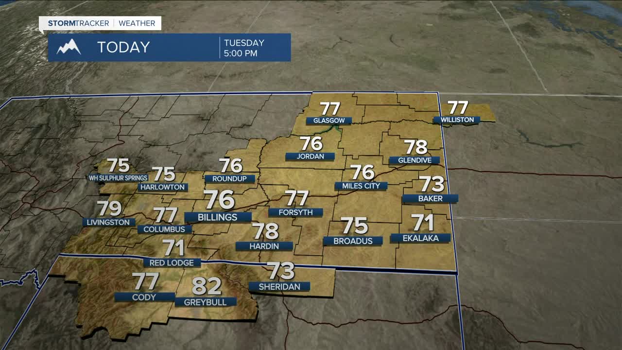


BILLINGS — High pressure ridging builds across the region on Tuesday, so dry conditions will prevail, but it will be cooler (still above average, though), with daytime highs mainly in the mid to upper 70s. It will be breezy at times, especially in the east, with gusts between 15-30 mph.
Dry conditions remain through Wednesday afternoon as the heat cranks back up, bringing the hottest temperatures of the week, with highs anywhere from 15 to 30 degrees above normal in the upper 80s to low 90s. Stay hydrated if you plan to be outside.
Winds out of the south are expected to increase over the area on Wednesday, with gusts between 20–30 mph, the strongest forecast across the western mountains and valleys as well as in the east.
While there is agreement among models that a trough will move in midweek, there is still some uncertainty on the timing. As of now, Wednesday afternoon/evening into Thursday seems to be the latest thinking. This will bring a chance of showers and thunderstorms to the west by late Wednesday afternoon. There could be some modest instability with any storms that pop up, producing gusts in excess of 45-55 mph. There is a MARGINAL (1 of 5) risk of severe storms to our west. There is a concern that some of the storms could be dry, so erratic wind gusts could create elevated fire concerns.
The trough is forecast to become an upper level low on Thursday as it slides across southern Canada. If this path holds true, then rain will stay confined to northeast MT, missing the rest of the area. Winds will remain strong across the region, though, with gusts out of the west between 40–55 mph forecast, especially across the foothills west of Billings where gusts could reach 60 mph. Elevated fire conditions will again be possible with these strong winds, warm temperatures, and mainly dry conditions.
The region will stay under the influence of an unstable weather pattern Friday through the weekend, with a few rounds of showers and thunderstorms possible.
Expect temperatures to gradually cool behind the system, with daytime highs in the 60s and 70s Thursday through Saturday, then upper 50s to low 60s on Sunday.
MOUNTAIN SNOWPACK
While no flooding is anticipated, be on the lookout for rising creeks, streams, and rivers this week as the warmer temperatures are accelerating snowmelt. Water will be very cold, and the currents and flow will be stronger. Use caution if you plan to get out on the water.
Miller Robson
Q2 Morning Meteorologist
miller.robson@ktvq.com
