

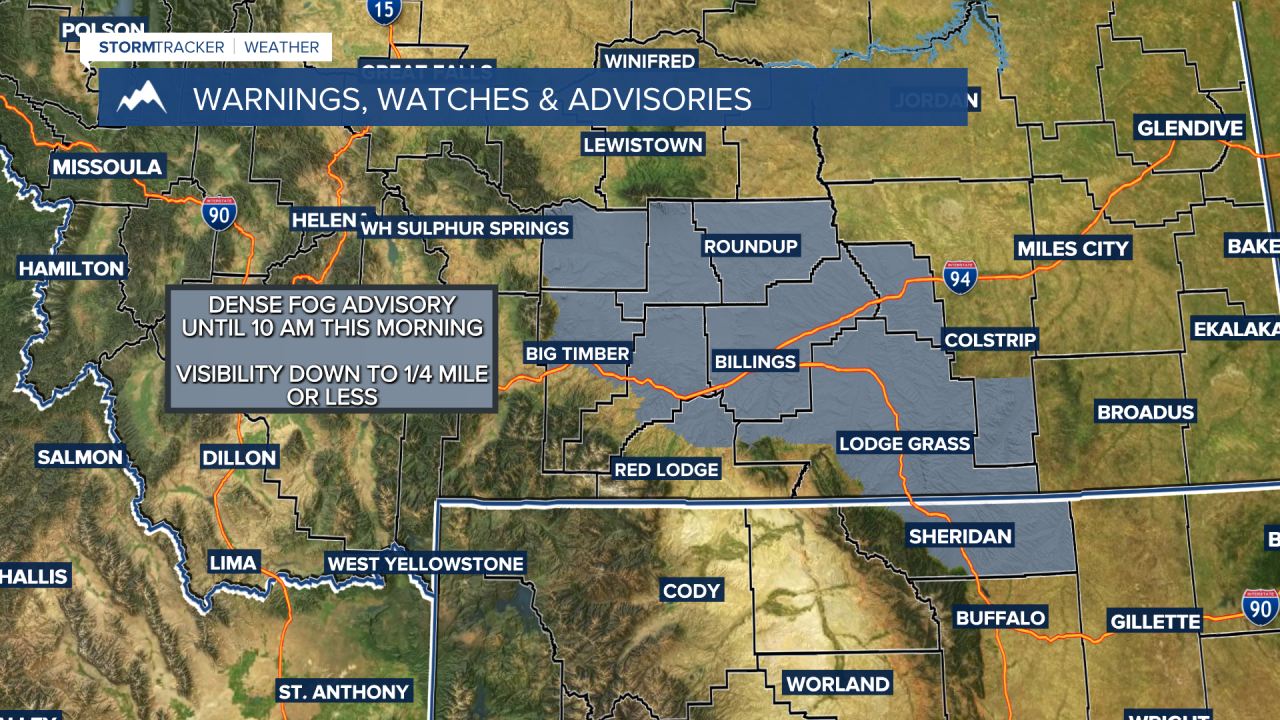


BILLINGS — Low clouds and fog are covering many lower-elevation locations this morning. Fog is expected to thicken up before sunrise as moisture settles in, with some spots dropping to a quarter-mile of visibility or less. Take it easy on your morning drive!
Most of the area stays dry for much of the week, though a quick-moving disturbance could bring scattered showers and isolated thunderstorms Tuesday night into Wednesday morning.
We can also expect a warm-up this week with afternoon highs climbing into the 70s Monday through Wednesday before reaching into the 80s the second half of the week.
By late week, models are showing a deep area of low pressure moving through the Pacific Northwest and northern MT. If this system does develop, it could bring a cool-down and a chance for rain. Something to keep an eye on as we get closer to the weekend.
Miller Robson
Q2 Morning Meteorologist
miller.robson@ktvq.com
——————————————————————-———————-
***WEEKEND RAINFALL FOLLOW-UP***
Both Billings and Miles City set new daily precipitation records on Saturday, September 19, 2026.
Billings recorded 1.28 inches, comfortably beating the 2000 record of 0.68 inches.
Miles City received 1.57 inches, topping the previous record of 0.96 inches from 1985.
The total at the Billings Airport reached 2.93 inches between Friday and Saturday, setting a brand-new September record for a two-day total. That passes the previous mark of 2.20 inches set back in 1966.
Month-to-date rainfall for Billings is already up to 4.49 inches. That places this September as the second-wettest on record for the city with 10 days still left in the month.
The all-time wettest September remains 1941 at 4.99 inches (weather records at the airport date back to 1934).
***PRELIMINARY PRECIPITATION REPORTS (SEPTEMBER 18–20, 2026)***
(This list doesn't include any reports turned in after 4 PM on Sunday, Sept 20)
MONTANA
Big Horn County
Pryor Mountain: 1.99 in (03:18 PM 09/20)
Little Bighorn: 1.94 in (03:59 PM 09/20)
Hardin 0.6 ENE: 1.51 in (09:06 AM 09/20)
Bighorn Mountain: 1.19 in (03:18 PM 09/20)
Hardin: 1.17 in (05:00 PM 09/19)
Wolf Mountain: 1.04 in (03:18 PM 09/20)
Fort Smith 0.5 ENE: 0.91 in (07:00 AM 09/20)
Carbon County
Joliet 2.2 WNW: 1.77 in (07:00 AM 09/20)
Fromberg: 1.63 in (07:00 AM 09/20)
Rockvale: 1.40 in (04:00 PM 09/20)
Fromberg 2.7 NE: 1.35 in (07:00 AM 09/20)
3 SW East Bridger: 0.64 in (04:00 PM 09/20)
Quad Creek: 0.61 in (04:25 PM 09/20)
Red Lodge 6.2 NNE: 0.54 in (07:00 AM 09/20)
Hillsboro: 0.52 in (04:29 PM 09/20)
Wild Horse: 0.51 in (04:48 PM 09/20)
Carter County
Mosby 16.3 NNE: 1.25 in (04:54 PM 09/20)
Ridge 3.8 NE: 0.66 in (07:00 AM 09/20)
Boyes 1.7 NNE: 0.63 in (08:00 AM 09/20)
Custer County
Miles City: 1.71 in (04:53 PM 09/20)
Volborg: 1.59 in (07:00 AM 09/20)
Miles City Portable_2014: 1.23 in (04:36 PM 09/20)
Knowlton: 1.08 in (04:40 PM 09/20)
Ismay 3.4 NE: 0.93 in (07:00 AM 09/20)
Fallon County
Cannonball Creek: 0.87 in (04:40 PM 09/20)
Baker: 0.54 in (04:51 PM 09/20)
Golden Valley County
9.4 NE Hedgesville: 0.60 in (07:00 AM 09/19)
Musselshell County
Roundup: 2.61 in (04:56 PM 09/20)
Roundup 13.9 S: 2.55 in (08:00 AM 09/20)
Roundup 4.3 SSE: 2.17 in (09:00 AM 09/20)
Horse Thief: 2.06 in (12:39 AM 09/20)
Broadview: 1.87 in (04:45 PM 09/20)
Roundup 0.6 NW: 1.73 in (07:00 AM 09/20)
Roundup 1.8 NNE: 1.49 in (08:00 AM 09/20)
Roundup 8.5 NNE: 1.39 in (08:00 AM 09/20)
Roundup 0.3 NE: 1.35 in (07:00 AM 09/20)
Roundup 3.0 NNE: 1.33 in (07:00 AM 09/20)
Roundup 6.2 ENE: 1.30 in (07:00 AM 09/20)
Park County
Wicked Creek: 1.05 in (04:07 PM 09/20)
Crazy: 1.02 in (04:12 PM 09/20)
Springdale: 0.95 in (08:00 AM 09/20)
Livingston 6.6 ESE: 0.75 in (07:00 AM 09/20)
Powder River County
Volborg 17.7 SW: 1.85 in (07:00 AM 09/20)
Broadus 18.8 NNW: 1.58 in (07:00 AM 09/20)
Volborg 15.1 SSW: 1.33 in (07:00 AM 09/20)
Broadus 21.9 SE: 1.01 in (06:30 AM 09/20)
Ashland 9.7 ESE: 0.91 in (07:00 AM 09/20)
Home Creek Divide US-212 MP: 0.89 in (04:45 PM 09/20)
Bradshaw Creek: 0.63 in (04:24 PM 09/20)
Coalwood MT-59 MP 55.9: 0.58 in (03:00 AM 09/20)
Ashland 14.8 E: 0.56 in (07:00 AM 09/20)
Biddle: 0.51 in (06:00 AM 09/20)
Rosebud County
Cow Creek: 2.54 in (03:21 PM 09/20)
13.1 NE Ingomar: 2.37 in (06:00 AM 09/20)
5 WSW Colstrip: 2.04 in (02:55 AM 09/20)
2 E Forsyth: 1.63 in (04:55 PM 09/20)
Forsyth: 1.62 in (05:00 PM 09/20)
1 ENE Forsyth: 1.54 in (05:00 PM 09/19)
0.9 E Brandenberg: 1.30 in (06:00 PM 09/19)
Badger Peak: 1.22 in (03:01 AM 09/20)
Mtnca_port1: 0.61 in (04:29 PM 09/20)
Stillwater County
Park City 6.0 WSW: 2.38 in (07:30 AM 09/20)
Columbus 8.2 ESE: 2.37 in (07:00 AM 09/20)
Columbus 7.2 E: 1.90 in (07:00 AM 09/20)
Custer No. 1 Portable: 1.37 in (03:18 PM 09/20)
Reed Point: 1.29 in (04:56 PM 09/20)
Reed Point 5 SE: 1.24 in (06:00 AM 09/20)
Columbus 6.0 SSE: 1.18 in (08:00 AM 09/20)
Nye: 1.17 in (04:48 PM 09/20)
Columbus: 1.11 in (10:01 AM 09/19)
Fishtail 18 SW: 0.55 in (04:00 PM 09/19)
Sweet Grass County
12 W Melville: 3.08 in (04:55 PM 09/20)
4.8 W Melville: 2.24 in (06:00 PM 09/19)
Melville 10.1 ENE: 1.76 in (07:00 AM 09/19)
Big Timber 11.3 NNE: 1.70 in (07:00 AM 09/19)
Derby Mountain: 1.61 in (04:35 PM 09/20)
Big Timber: 1.40 in (04:45 PM 09/20)
Main Boulder: 0.81 in (04:39 PM 09/20)
Treasure County
Hysham 25 SSE: 1.94 in (08:00 AM 09/20)
Wheatland County
2 WNW Barber: 3.50 in (11:21 AM 09/19)
2 ENE Harlowton: 1.32 in (04:55 PM 09/20)
Yellowstone County
1 ENE Billings: 3.22 in (05:43 PM 09/19)
Billings 1.9 WNW: 3.03 in (07:00 AM 09/20)
Billings: 3.00 in (04:53 PM 09/20)
Billings 1.7 W: 2.63 in (07:00 AM 09/20)
Billings 4.5 NE: 2.62 in (08:30 AM 09/20)
3.8 E Huntley: 2.56 in (08:00 AM 09/20)
Billings 3.2 NNE: 2.46 in (07:00 AM 09/20)
3.1 E Billings: 2.44 in (09:00 AM 09/20)
Billings 5.2 WSW: 2.30 in (04:20 PM 09/19)
3 SW Billings: 2.30 in (04:30 PM 09/19)
Soda Springs: 2.30 in (03:21 PM 09/20)
Billings 4.3 S: 2.26 in (07:30 AM 09/20)
1 W Billings: 2.25 in (09:39 AM 09/19)
1 SSW Lockwood: 2.25 in (01:47 PM 09/19)
Billings: 2.04 in (04:55 PM 09/20)
6 W Billings: 2.04 in (04:55 PM 09/20)
2 NNE Billings: 1.70 in (08:00 PM 09/19)
1 ESE Pompeys Pillar: 1.60 in (02:40 PM 09/19)
15.4 N Pompeys Pillar: 1.59 in (07:00 AM 09/20)
Steamboat: 1.58 in (04:41 PM 09/20)
Billings 4.2 WSW: 1.12 in (07:44 AM 09/19)
3.8 E Huntley: 1.02 in (08:00 AM 09/19)
WYOMING
Sheridan County
Story: 1.81 in (04:45 PM 09/20)
0.6 W Story: 1.03 in (08:03 AM 09/20)
Story 1.1 W: 0.99 in (06:00 AM 09/20)
Story 2.1 W: 0.81 in (07:00 AM 09/20)
2.9 E Beckton: 0.80 in (04:30 PM 09/20)
Big Goose: 0.70 in (10:00 AM 09/19)
1 W Story: 0.64 in (04:55 PM 09/18)
Burgess Junction: 0.60 in (04:00 PM 09/20)
Sheridan: 0.57 in (04:48 PM 09/20)
Sheridan 7.2 WSW: 0.51 in (09:00 AM 09/20)
Dome Lake: 0.50 in (03:00 PM 09/20)
Banner: 0.50 in (04:55 PM 09/20)
