

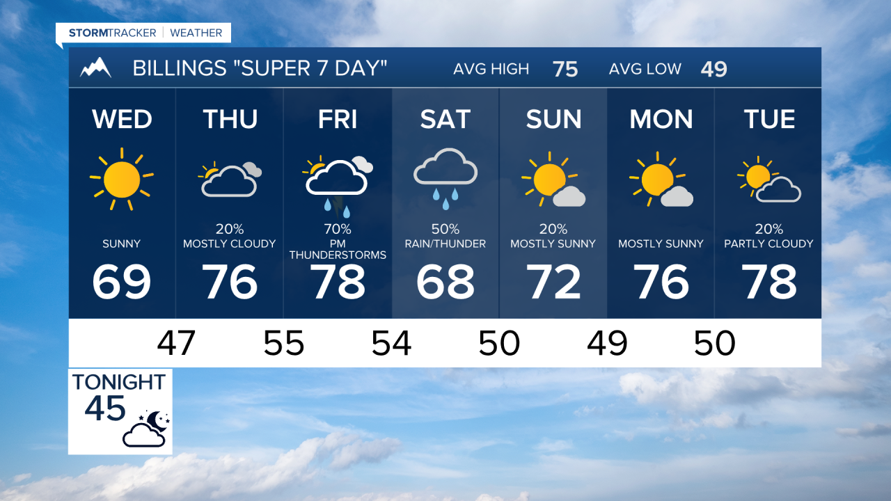

BILLINGS — A quiet stretch of weather is in place through Wednesday, but a much more active pattern develops late this week with increasing rain chances. The potential for strong thunderstorms develops east of Billings Friday, and a wetter outlook through the weekend. Some locally heavy rainfall is possible Friday into Saturday.
TONIGHT
Clear to mostly clear skies continue across Billings and south central/southeast Montana and northern Wyoming. Winds turn southerly overnight, becoming breezy across exposed areas of southeastern Montana. Overnight lows range from the upper 30s in cooler valleys to near 50 degrees in the far east.
WEDNESDAY
Another dry day with a mix of sunshine and occasional clouds. A reinforcing shot of cooler air arrives on northerly winds, but no precipitation is expected. Highs reach the 60s across most of the area, with lower to mid 70s farther east.
WEDNESDAY NIGHT
Moisture begins returning from the southeast. Most areas remain dry, but isolated showers could begin developing across southeastern Montana late at night.
THURSDAY
Weather turns more active. Scattered showers and a few thunderstorms develop, especially across southeastern Montana and the mountains. Severe weather is not expected, but some storms could be briefly stronger. Temperatures warm into the 70s, with a few lower 80s possible in central sections.
FRIDAY
This looks to be the most impactful day of the forecast period. Deep moisture spreads across the region with widespread showers and thunderstorms developing. Strong thunderstorms are possible east of Billings, particularly from Sheridan County through eastern portions of southeast Montana. Heavy rainfall will also become a concern as moisture levels climb well above normal. Highs reach the 70s to lower 80s before clouds and precipitation increase.
SATURDAY
A wet and unsettled day appears likely. Numerous showers and thunderstorms continue across south central and southeast Montana as a slow-moving upper low moves through the region. Locally heavy rainfall remains possible. Temperatures cool back toward 70 degrees. Travelers and outdoor enthusiasts in the higher mountains should be prepared for rain and even some light snow above 10,000 feet.
SUNDAY
Showers persist, especially across eastern sections of southeast Montana, as the storm system slowly exits into the Northern Plains. Temperatures remain near 70 degrees with periods of clouds and rain.
MONDAY
Dry conditions return with increasing sunshine and warmer temperatures. Afternoon highs climb back into the mid to upper 70s.
LOOKING AHEAD
The quiet weather of midweek gives way to a much wetter pattern Thursday through Sunday. Friday and Saturday currently appear to offer the highest potential for widespread rain, locally heavy rainfall, and a few strong thunderstorms east of Billings. Conditions improve significantly by Monday with warmer and drier weather returning.
