

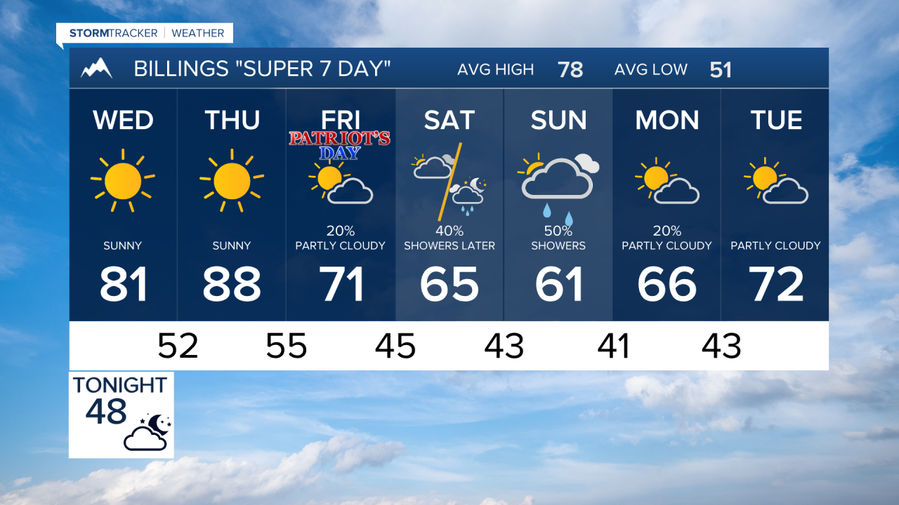


BILLINGS — A brief taste of fall is on the way for Billings and the region, but not before a couple of warm and breezy late-summer days. A stronger weather system arriving this weekend could bring the coolest temperatures of the season so far, along with the potential for the first frost in some locations.
WEDNESDAY
After a cool start, temperatures will rebound into the upper 70s and lower 80s with breezy west winds developing during the afternoon, especially near the foothills and higher terrain. Overall, it will be a pleasant early September day with low humidity and increasing fire weather concerns.
THURSDAY
Thursday looks to be the warmest day of the week as the lower elevations should climb well into the 80s, with some locations approaching 90 degrees. Warm temperatures, low humidity, and gusty winds will create elevated to critical fire weather conditions, particularly west of Billings and along the foothills. Outdoor burning is strongly discouraged.
FRIDAY
Changes begin arriving Friday as a new weather system approaches from the west. Temperatures will trend cooler, generally falling back into the 70s. Clouds will increase, and the chance for scattered showers will begin to rise across the region. While not everyone will see rain, the overall pattern becomes noticeably less summer-like.
SATURDAY
Cooler air settles into Montana and northern Wyoming Saturday. High temperatures will mostly range through the 60s, with scattered showers possible across the area. Outdoor plans may need a backup option as periods of rain become more likely. Mountain locations could see the first meaningful taste of wintry weather at the highest elevations.
SUNDAY
Sunday appears to be the coolest day of the stretch. Temperatures may struggle to get out of the upper 50s to lower 60s around Billings, with continued chances for showers. Higher elevations could see accumulating mountain snow, while lower elevations experience a much more autumn-like feel than recent weeks.
MONDAY
Chilly mornings become the story. Forecast guidance suggests some foothill communities and colder valleys could flirt with their first frost of the season, while much of south central and southeast Montana experiences one of its coldest mornings since spring. Afternoon temperatures should begin a modest rebound as conditions gradually improve.
TUESDAY
The warming trend continues with drier weather returning to much of the region. Temperatures should recover into the upper 60s and lower 70s, providing a more comfortable and seasonable start to the new week while lingering cool mornings remain possible.
