

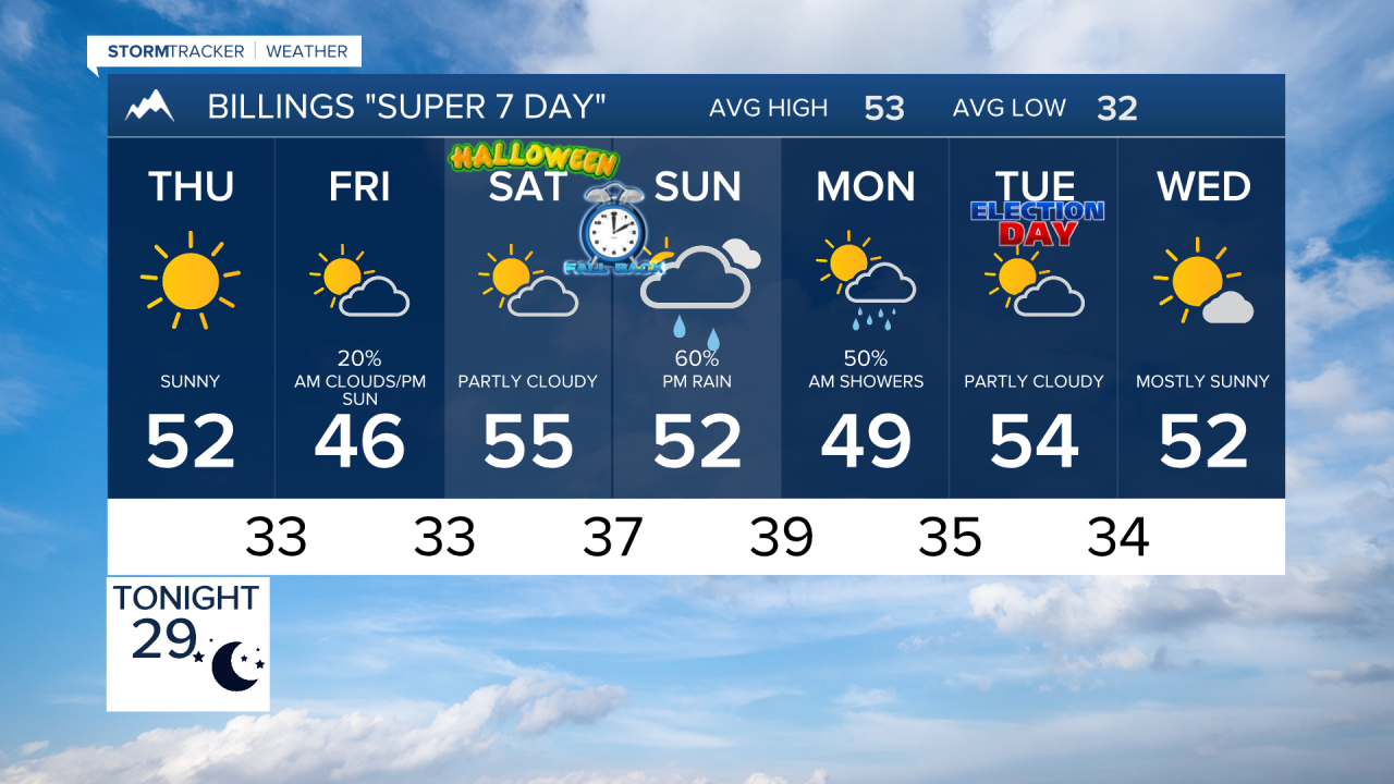

BILLINGS — A mainly dry and seasonable stretch continues through Friday before the pattern becomes more active this weekend. Rain and mountain snow chances begin increasing Saturday, followed by the potential for a cooler, wetter and windier storm system Sunday into Monday.
WEDNESDAY
Look for a mostly dry and seasonable day across south-central and southeast Montana and northern Wyoming. Highs will reach the 50s to lower 60s with breezy west winds at times. Gusts could reach the 30s mph along the foothills west of Billings. A few morning snow showers are possible in the Absaroka-Beartooths, with only a slight chance of a light rain or snow shower near the Montana-Wyoming line in far southeast Montana.
THURSDAY
A Canadian cold front will push into the region and turn winds more easterly. Otherwise, the weather remains mainly dry and seasonable with highs largely in the 50s. Thursday night could bring areas of fog and low clouds, something to watch heading into Friday morning.
FRIDAY
Another mainly dry day is expected as the region sits between low pressure to the west and high pressure farther east. Temperatures remain seasonable, generally in the upper 40s to middle 50s. Clouds may begin increasing later as the next weather system approaches.
SATURDAY
The pattern begins changing. Increasing moisture and disturbances ahead of the approaching western storm will bring isolated showers, especially over the mountains and foothills. Lower elevations should remain relatively mild, with highs mostly in the 50s to near 60.
SUNDAY
The chance for precipitation increases as the storm system moves closer. Rain and mountain snow become more likely, while temperatures begin trending cooler. The exact track of the storm remains uncertain, so precipitation amounts, snow levels and wind impacts are still subject to change.
MONDAY
Monday currently has the best chance for widespread precipitation as the storm moves through the region. Cooler temperatures, rain and mountain snow are possible across south-central and southeast Montana and northern Wyoming, along with potentially windy conditions. Highs could fall into the upper 40s and lower 50s in many lower-elevation communities.
TUESDAY
Conditions should begin improving behind the storm. High pressure is expected to return, bringing somewhat warmer and drier weather back to the region.
