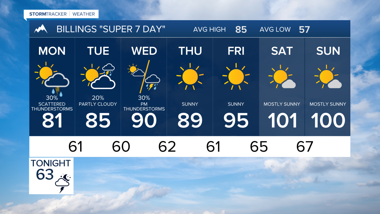

BILLINGS — Scattered thunderstorms remain in the forecast through midweek, but attention is already turning toward a potentially dangerous heat wave next weekend. Temperatures could soar into the triple digits, making it the hottest stretch of 2026 so far.
SUNDAY: Isolated thunderstorms will develop over the mountains this afternoon before drifting northeast across the plains through the evening. Any storm could produce strong wind gusts, with the highest risk west and north of Billings. A few stronger storms are also possible near the eastern Montana border. Highs will reach the 90s.
MONDAY: Cooler air arrives with highs mainly in the 80s as northeasterly winds increase low-level moisture. Thunderstorm chances increase late in the day, with showers and wet thunderstorms becoming more widespread by evening. Heavy rainfall will be possible as atmospheric moisture continues to build.
TUESDAY: Periods of showers and thunderstorms continue, especially across area north and east of Billings. Some locations could receive significant rainfall, with the greatest potential near Miles City and Baker. While the severe weather threat remains low, a few stronger storms cannot be ruled out in the east. Temperatures remain seasonable.
WEDNESDAY: Another disturbance will support scattered thunderstorms across the region. Heavy rain remains possible in stronger storms, though the overall severe weather threat appears limited. Temperatures stay near seasonal averages in the 80s to low 90s.
THURSDAY: A gradual drying trend begins. Most areas will see lower thunderstorm coverage, with only isolated storms possible, mainly across eastern Montana. Temperatures begin to edge upward.
FRIDAY: Continued warm-up with only a slight chance of isolated thunderstorms in the east. More highs reach the 90s. Most locations should remain dry as high pressure strengthens over the western U.S.
SATURDAY: Confidence is increasing in a significant heat event. High temperatures are expected to reach or exceed 100 degrees across much of south-central and southeast Montana, especially from Billings eastward. There is a growing risk of heat-related impacts for outdoor activities.
SUNDAY: Very hot conditions continue, with triple-digit temperatures remaining possible. This could become the hottest stretch of weather so far this year, and residents should monitor forecasts closely as confidence continues to increase.
