

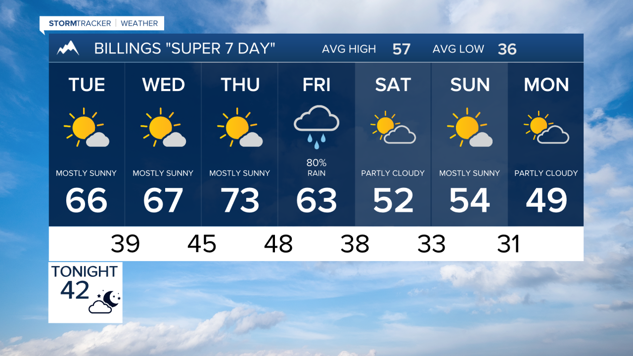

BILINGS — Mild and mainly dry weather holds through Thursday across south-central and southeast Montana and northern Wyoming. Then the pattern turns much more active Friday into Saturday with a strong cold front, increasing wind, widespread precipitation and mountain snow.
MONDAY NIGHT: Winds gradually diminish across eastern Montana this evening. Otherwise, expect a quiet and mainly dry night with lows mostly in the 30s and 40s.
TUESDAY: A dry cold front moves through, but temperatures remain seasonably mild. Highs reach mainly the 60s and lower 70s with mostly dry conditions, although a stray shower is possible in the Absaroka-Beartooth Mountains.
WEDNESDAY: Mild and quiet weather continues. Most lower elevations stay dry with highs generally in the 60s to around 70, while the mountains carry only a slight chance for precipitation.
THURSDAY: This should be the warmest day of the week, with widespread 70s across the lower elevations. Conditions remain mainly dry, but winds begin increasing late Thursday into Friday across the Bighorn Mountains, where southwest gusts of 30 to 50 mph are possible.
FRIDAY: A strong weather system begins changing the pattern. Temperatures turn cooler as a cold front moves through, accompanied by increasing rain chances and stronger winds. There is a decent chance for gusts over 40 mph across the region late Friday into Saturday morning, with a few gusts potentially reaching 50 mph around Wheatland County and Sheridan County, Wyoming. Precipitation chances climb above 70% across parts of south-central Montana and northwestern and central Wyoming.
SATURDAY: Cooler, windy and unsettled conditions continue. Rain is expected across the plains, while snow levels fall from around 10,000 feet to near 5,000 feet, bringing accumulating snow to the mountains. The Absaroka-Beartooths have about a 50% chance of receiving 6 inches or more of snow. South-central Montana also has a 50% to 80% chance of receiving at least a half-inch of liquid precipitation, with lower chances farther east.
SUNDAY: The storm begins pulling away and conditions trend drier as high pressure starts rebuilding. Temperatures remain considerably cooler than the midweek warmth, with highs mainly in the 50s across the lower elevations.
