

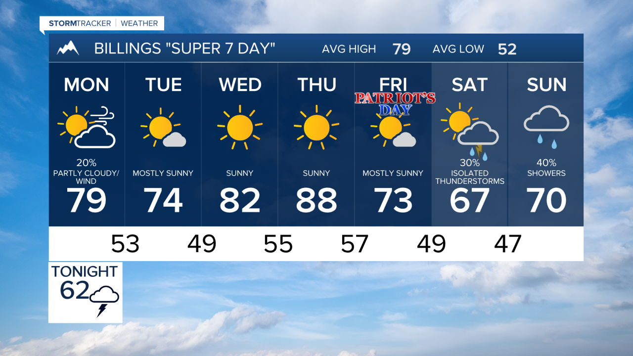


BILLINGS — A couple rounds of showers and thunderstorms will move through Billings, south-central and southeast Montana, and northern Wyoming through Monday before strong winds take over early this week. Drier and warmer weather returns by midweek, but another potentially cooler storm system may arrive next weekend.
SUNDAY NIGHT
A weather disturbance moving ahead of an approaching low-pressure system will trigger scattered showers and thunderstorms across much of the region tonight. The highest coverage is expected from Billings westward into the foothills and mountains of south-central Montana, where precipitation chances rise as high as 70 percent. A few storms could become strong, producing localized heavy rainfall, hail, and gusty winds. Storm activity will gradually diminish toward daybreak Monday.
MONDAY
After a brief lull early in the morning, another round of isolated to scattered showers and thunderstorms develops by late morning and afternoon. Storms will move eastward across south-central and southeast Montana and into northern Wyoming. Severe weather is not expected to be widespread, but locally strong wind gusts remain possible. The bigger story will be increasing west winds, especially from Livingston and Big Timber to Harlowton, where gusts could approach 50 mph during the afternoon and evening. Billings and surrounding communities can expect a breezy to windy day with elevated fire weather concerns.
MONDAY NIGHT
Showers and thunderstorms taper off through the evening as the storm system shifts east. Strong west winds continue across much of the region, especially near the foothills and adjacent plains. Areas of blowing dust and difficult travel conditions may develop in the windiest locations.
TUESDAY
Windy conditions persist across southeast Montana and northern Wyoming. Gusts of 20 to 40 mph will be common, with isolated gusts near 50 mph possible toward Baker and far eastern Montana. Drying conditions spread across the region, but elevated fire weather conditions remain a concern due to the combination of wind and dry fuels.
WEDNESDAY
Dry weather settles in across Billings and the surrounding region. Sunshine becomes more widespread, and temperatures rebound to above seasonal averages. Winds will be lighter, creating pleasant early-autumn conditions.
THURSDAY
Another dry and warm day is expected across south-central and southeast Montana and northern Wyoming. Afternoon temperatures climb above normal with a mix of sunshine and occasional fair-weather clouds.
FRIDAY
Forecast confidence begins to decrease as another storm system approaches from the western United States. Increasing cloud cover and cooler temperatures are possible by late in the day, with a slight chance of showers beginning to return.
SATURDAY
Current forecast trends suggest a cooler and more unsettled weather pattern could develop across the region. Periods of showers may return, and temperatures could fall noticeably compared to the middle of the week. Details remain uncertain, but confidence is increasing that a weather change is on the horizon.
SUNDAY
The potential exists for continued cool and unsettled conditions across south-central and southeast Montana and northern Wyoming. While confidence in exact timing and precipitation amounts remains low, the overall pattern favors a greater chance of showers and below-normal temperatures compared to the warmth expected during the middle of the week.
