

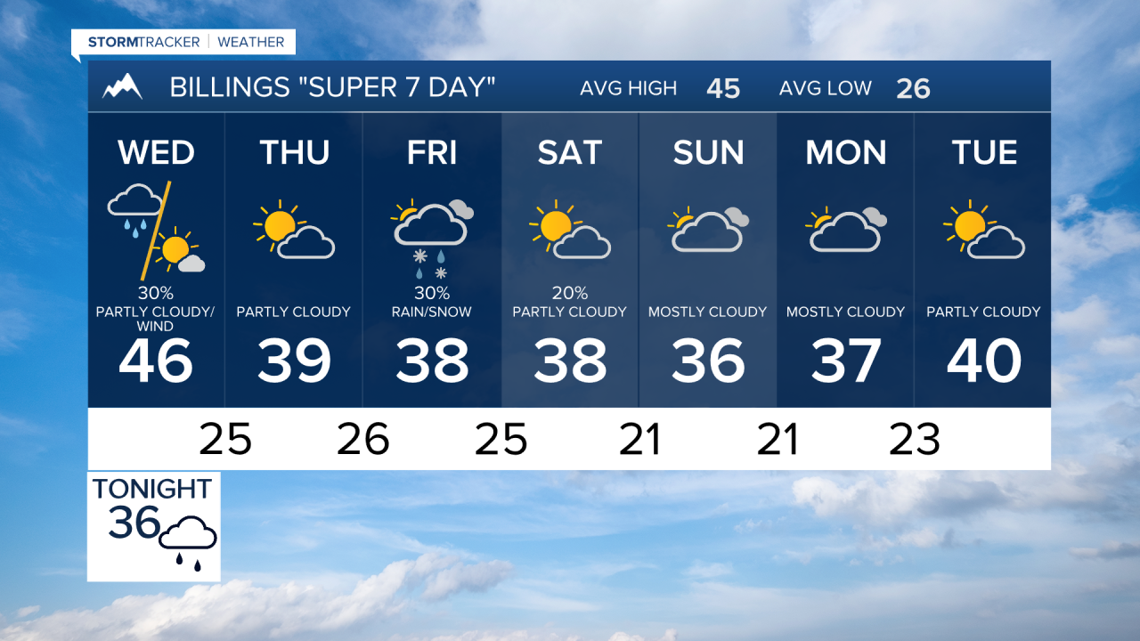

BILLINGS — Rain and snow spread across south-central and southeast Montana and northern Wyoming tonight, followed by strong west to northwest winds Wednesday. Cooler, more seasonable weather settles in behind the system, with another chance for snow late in the week into the weekend.
TUESDAY NIGHT
Clouds will continue to increase as a storm system moves out of the Great Basin, with rain and snow showers developing across south-central Montana before spreading east overnight. Most locations west of a Sheridan-to-Baker line could receive at least a tenth of an inch of precipitation, with locally higher amounts southeast of Billings.
Snow will become more common as colder air arrives. Around an inch is possible near Livingston, with 2 inches or more in Paradise Valley and substantially higher amounts in the mountains. Bozeman Pass could receive as much as 6 inches. Snow and blowing snow may create difficult travel around Livingston and Judith Gap.
WEDNESDAY
Rain and snow showers will move east across the region through the day as the storm tracks from southeast Montana into the Dakotas. Lower elevations may see precipitation increasingly mix with or change to snow during the morning, while mountain snow continues.
Strong west to northwest winds become the biggest concern. Gusts over 40 mph will be widespread, with winds potentially reaching the 50s along the US-191 corridor for a time. The strongest winds are expected across far southeast Montana, including around Baker, where frequent gusts in the 50s and occasional gusts into the 60s mph are possible.
Strong mountain-wave winds could also briefly develop near Sheridan and the Bighorn Mountains. Temperatures will turn noticeably cooler, with highs generally in the lower to middle 40s.
THURSDAY
Weak high pressure brings a quieter and mainly dry day. Winds ease and temperatures remain seasonably cool, with highs around 40 to the lower 40s. Areas of morning fog could develop where skies clear and winds become light, especially where ground moisture remains from Tuesday night's and Wednesday's precipitation.
FRIDAY
The next weather system approaches, bringing another chance for precipitation. Temperatures remain cool, with highs generally in the upper 30s to lower 40s. Snow becomes possible across portions of the region, although confidence in amounts remains limited.
SATURDAY
Chances for rain and snow continue as the late-week system moves through. Current trends favor a weaker and farther-south storm, which would limit snowfall across much of south-central and southeast Montana and northern Wyoming. Most lower-elevation snowfall currently looks light, generally less than an inch, although locations above 4,000 feet could pick up around 1 to 2 inches and mountain areas could receive several inches.
SUNDAY THROUGH TUESDAY
Cool and generally seasonable conditions continue into early next week. Highs across the lower elevations should remain mainly in the 30s to lower 40s. A few lingering opportunities for light rain or snow remain, but at this point there is little indication of a major winter storm.
