

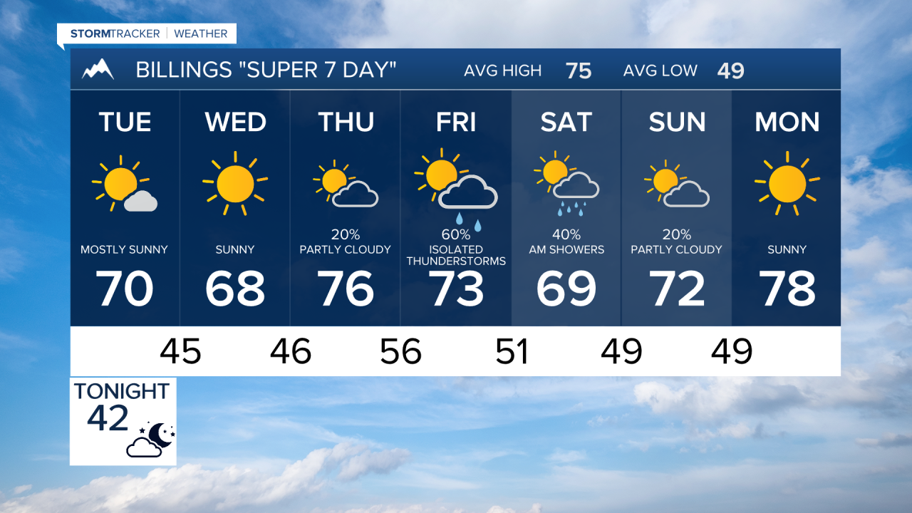

BILLINGS — A cool, windy start to the week will give way to a gradual increase in clouds and moisture, with the best chances for widespread rain and thunderstorms arriving Friday into Saturday across Billings, south central and southeast Montana, and northern Wyoming.
MONDAY NIGHT
Winds decrease quickly this evening after a blustery day across the region. Skies become mostly clear overnight, and temperatures fall into the 30s west of Billings and the low to mid 40s farther east. Patchy fog may develop along the Yellowstone River Valley, including near the Billings area, by early Tuesday morning. Gardeners in foothill communities and colder valleys should be prepared for areas of frost.
TUESDAY
Sunshine across most locations from Billings to Miles City and Sheridan, with highs generally in the mid 60s to mid 70s. Easterly breezes develop during the afternoon, helping keep temperatures a bit below seasonal averages.
WEDNESDAY
Another push of cooler air arrives from the north. Expect a mix of sun and increasing clouds with temperatures mostly in the 60s across south central Montana and northern Wyoming. Areas near the Wyoming border and far southeast Montana could still reach the lower to middle 70s before the cooler air settles in. Dry weather is expected for most locations.
THURSDAY
The weather pattern begins to change as a Pacific storm system approaches the Northern Rockies. Clouds increase through the day, and isolated to scattered showers and thunderstorms develop by afternoon and evening. The higher terrain west and south of Billings has the best chance of seeing early rainfall. High temperatures rebound into the 70s.
FRIDAY
This looks to be the most active day of the forecast period. A steady feed of Pacific moisture combines with increasing southeast winds, bringing widespread showers and thunderstorms to much of south central and southeast Montana and northern Wyoming. Rain chances rise significantly across the region, and some locations could pick up meaningful rainfall. Highs remain comfortable in the 70s, with lower 80s possible near the Wyoming border east of Sheridan.
SATURDAY
Periods of showers and a few thunderstorms continue, especially during the first half of the day. Current indications suggest the heaviest rainfall potential may favor southeast Montana, including areas around Miles City and Baker. Temperatures remain seasonably cool, with highs mainly in the lower 70s. Rain coverage should gradually decrease later in the day and Saturday night.
SUNDAY
The storm system weakens and moves away, leading to improving conditions. Most areas across Billings, southeast Montana, and northern Wyoming should turn drier with a mix of sunshine and clouds. A stray lingering shower cannot be ruled out, but the overall trend favors a quieter and more comfortable end to the weekend with temperatures in the lower 70s.
