

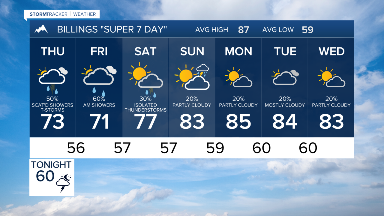

BILLINGS — Cooler air, widespread rain, and dramatically improved air quality will replace the recent stretch of heat, smoke, and dry weather, with the best chance for heavier rainfall and localized flooding east of a Roundup-Billings-Sheridan line.
WEDNESDAY NIGHT
The first wave of storms shifts east during the evening, but another disturbance arrives later tonight. Showers and additional thunderstorms spread from west to east overnight. While severe weather is not expected outside of extreme southeast Montana, thunder and periods of moderate to heavy rain may continue through the night.
THURSDAY
A brief morning lull gives way to another round of showers and thunderstorms during the afternoon, mainly across eastern portions of the region. Severe weather is unlikely, but widespread rainfall becomes increasingly likely. Temperatures continue to fall below seasonal averages to mainly the 70s as northerly winds and abundant cloud cover settle in. Air quality also improves as smoke is flushed from the region.
THURSDAY NIGHT
One of the wetter periods of the forecast is expected Thursday night into Friday morning. Deep moisture from both the Plains and the Southwest combines with several passing weather disturbances to produce widespread rain. Locally heavy downpours are possible, especially east of a Roundup to Billings to Sheridan line where the risk for excessive rainfall is greatest.
FRIDAY
Cool, unsettled weather continues with widespread showers and periods of rain. Temperatures remain well below normal, with many communities struggling only to the mid-60s to 70s. Beneficial rainfall is expected across much of the area, and while isolated flooding cannot be ruled out, there appears to be a relatively low overall flood threat.
SATURDAY
The wet pattern remains in place as additional waves move through persistent southwesterly flow aloft. Periods of showers and scattered thunderstorms continue, with occasional heavier rainfall possible. Temperatures stay unusually cool for mid-August with 50s early and 70s for highs. Air quality remains good.
SUNDAY
Rain chances gradually diminish as the deepest moisture begins to retreat, though scattered showers and thunderstorms remain possible. Temperatures may begin a slow recovery but are still expected to remain below average.
MONDAY
A weak ridge attempts to build into the Northern Rockies, leading to less overall rain. Isolated afternoon and evening showers or thunderstorms remain possible, but coverage should be lower than during the weekend. Temperatures continue to warm, now reaching the upper 70s and 80s.
TUESDAY
Seasonal temperatures gradually return as the atmosphere becomes somewhat less active. However, the overall pattern still favors occasional afternoon and evening showers and thunderstorms. The recent hot, dry, and smoky weather pattern appears unlikely to return through at least the middle of next week.
