

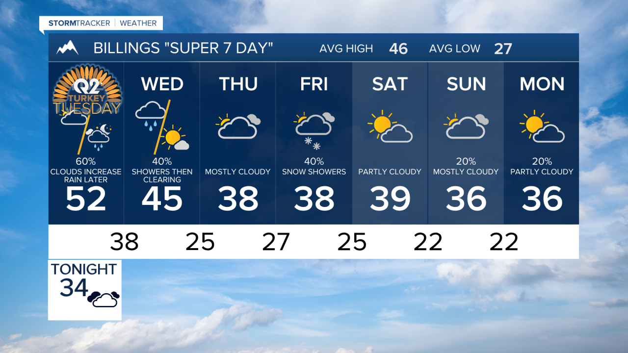

BILLINGS — Warm and dry weather continues into Tuesday across south-central and southeast Montana and northern Wyoming, but a midweek system will bring rain, mountain snow and gusty winds. A potentially more significant system could bring lower-elevation snow and travel impacts late in the week, although the details remain uncertain.
TUESDAY
Tuesday will be the last warm day of the week. Highs will range from the upper 40s northwest of Billings to the lower 60s across southeast Montana and northern Wyoming. Most of the day remains dry, but changes arrive Tuesday night as a storm system moves out of the Great Basin, increasing the chances for rain and mountain snow.
WEDNESDAY
Rain and snow will become more widespread before gradually ending from west to east during the day. Lower elevations should see mainly rain, although wet snow could mix in or briefly take over across some higher terrain east of Billings, including the Wolf Mountains, Hysham Hills and Lame Deer Divide. The western mountains could receive roughly 3 to 6 inches of snow, with locally higher amounts possible in the Absarokas.
Winds will also increase behind the system, with west to northwest gusts of 30 to 45 mph possible, particularly across eastern Montana and along the east slopes of the Bighorns. Temperatures will fall into the lower to middle 40s, making Wednesday feel noticeably colder than the exceptionally mild weather earlier in November.
THURSDAY
A brief break between systems should bring generally dry weather Wednesday night into Thursday. Much cooler air will remain in place, with afternoon temperatures mainly in the upper 30s to middle 40s.
FRIDAY
Another Pacific system could bring a renewed chance of precipitation along with even chillier temperatures. Snow levels may become low enough for snow at lower elevations, potentially giving some locations east of the foothills their first snow of the season. There is still considerable uncertainty over where the heaviest precipitation develops and how much snow falls.
SATURDAY
The late-week system may linger into Saturday, with snow and possible travel impacts remaining a concern. Southeast Montana could potentially see snow accompanied by gusty winds if a surface low develops favorably to the east, but confidence in that exact scenario remains low. Forecast guidance currently favors conditions gradually drying during Saturday.
SUNDAY
Temperatures should remain near to slightly below normal for the weekend. Sunday may provide another relative break, although another Pacific disturbance could approach by Sunday or Monday, bringing the potential for another round of unsettled weather.
