

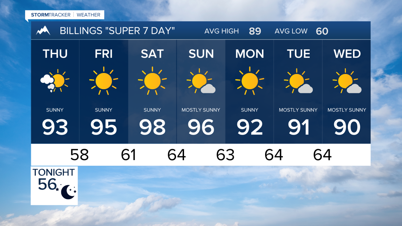

BILLINGS — Hot, dry, and smoky conditions will dominate southern Montana and northern Wyoming through the weekend, with elevated to critical fire weather concerns and temperatures pushing well into the 90s. A gradual pattern change may arrive late next week, bringing a chance for more active weather.
THURSDAY
Temperatures climb into the lower 90s across much of the region under mostly dry skies. Very low humidity and increasing winds behind a dry cold front will create elevated fire weather conditions area-wide, with locally critical conditions possible across the eastern plains. Some haze and smoke may linger, but widespread air quality impacts are not expected.
FRIDAY
Warmth continues to build as highs rise further into the 90s. Dry conditions continue, and fire weather concerns remain elevated due to low humidity and periodic gusty winds. Smoke may increase at times, creating hazy skies.
SATURDAY
The hottest stretch of the forecast arrives, with most locations reaching the upper 90s. Forecast guidance has trended slightly cooler than earlier projections, making 100-degree temperatures less likely but possible in some valleys. Dry weather continues, and fire danger remains high. Wildfire smoke from the Pacific Northwest may contribute to hazy conditions.
SUNDAY
Little change is expected. Above-normal temperatures, dry conditions, and elevated fire weather concerns continue. Smoke may drift across portions of southern Montana and northern Wyoming, though the greatest concentrations are expected to remain aloft. Brief periods of reduced air quality remain possible.
MONDAY
An upper-level ridge strengthens over the region, keeping us warm and dry. Hazy skies may persist due to regional wildfire smoke. Fire weather concerns continue as humidity remains low.
TUESDAY
Above-average temperatures continue with mostly dry conditions. Some weak monsoonal moisture may begin to work into the area, bringing a slight chance of isolated high-based showers or thunderstorms, though widespread precipitation is not expected.
WEDNESDAY
Forecast is more uncertain by midweek. Warm temperatures and hazy skies are expected to continue, but there are increasing signals that a low pressure system could begin breaking down the ridge later in the week, potentially leading to a more active weather pattern.
