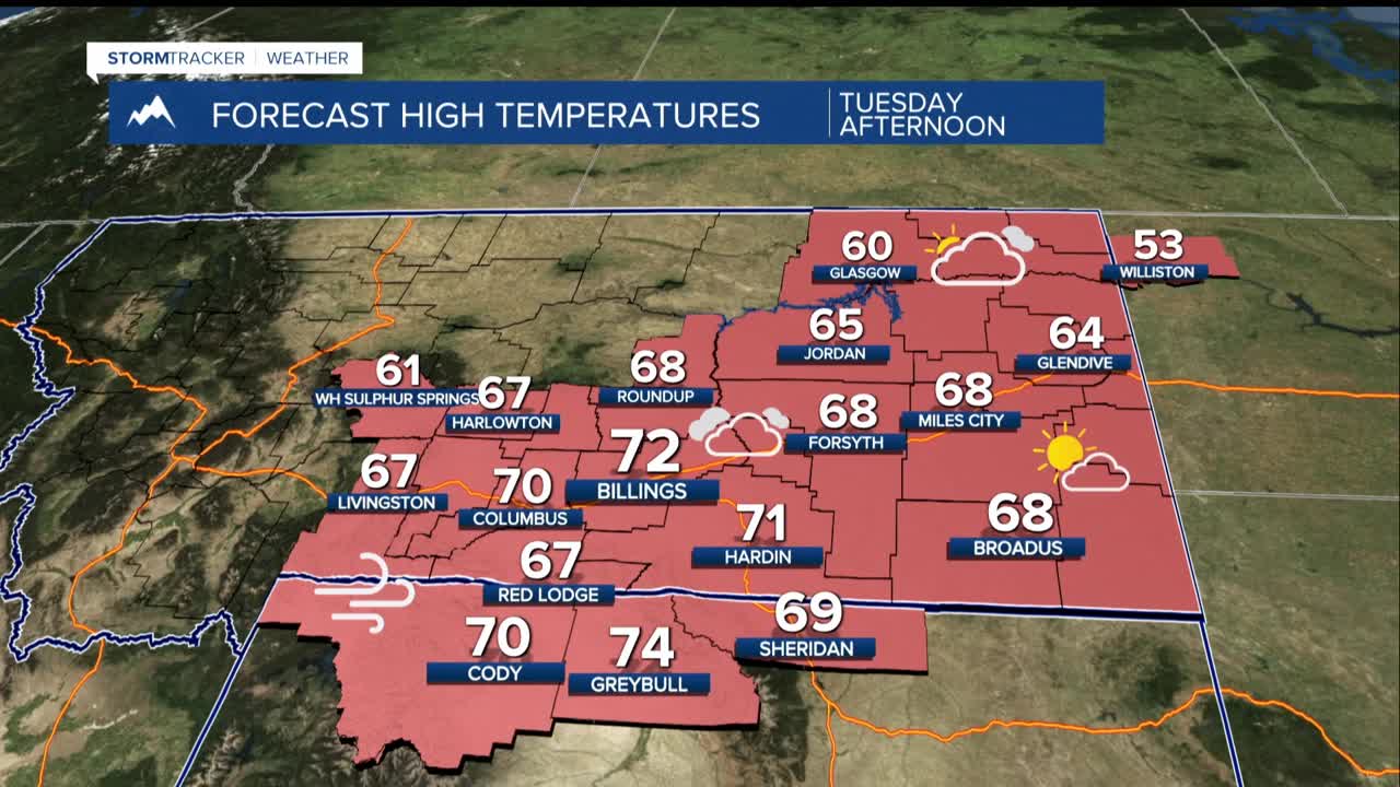


BILLINGS — TODAY THROUGH TUESDAY: Conditions settle into a warm and dry stretch to start the week. Tuesday brings highs in the 60s and 70s across the region, running a remarkable 10 to 20 degrees above what's typical for this time of year. A weak wave nudging through the mountains overnight Tuesday could squeeze out a few showers in the higher terrain to the west, but for most of us, it's just a warm and pleasant day.
However, that same wave is enough to spin up an inversion over the Paradise Valley and a modest pressure gradient, meaning Livingston and the Nye area will need to keep an eye on crosswinds Tuesday night into Wednesday. There is a 40% chance of gusts hitting 60 mph or greater.
WEDNESDAY: Upper ridging pushes temperatures soaring into the 70s and even 80s across much of the area 0r 20 to 30 degrees above normal. Record daily highs should be set somewhere in the area. Add relative humidity values dropping into the single digits and teens, plus gusts reaching 60 mph or greater. Even out on the plains toward Billings and east, gusts of 20 to 40 mph are expected.
Fire Weather Watches are in effect from noon to 9 PM Wednesday for south-central Montana and northern Wyoming. A single spark under these conditions could mean disaster. Please be extremely cautious.
WEDNESDAY EVENING THROUGH THURSDAY: The cold front finally makes its move Wednesday evening sweeping through the area and slamming the brakes on the heat and wind. Thursday highs fall back into the 40s to low 50s.
The front brings some scattered showers to the plains, though widespread precipitation is not expected. A second wave following close behind bumps up the rain and rain/snow showers across the area. In the mountains, light snow accumulations of 1 to 3 inches are currently forecast.
FRIDAY THROUGH THE WEEKEND: The cold snap is short-lived. Upper ridging builds back in heading into the weekend, and with it, Friday brings highs back into the 50s, followed by a return to the 60s and 70s Saturday and Sunday.
Conditions once again turn dry and settled. No widespread or significant precipitation events are in the forecast for the foreseeable future, meaning fire weather awareness will remain a consideration as we move through the coming weeks.
