

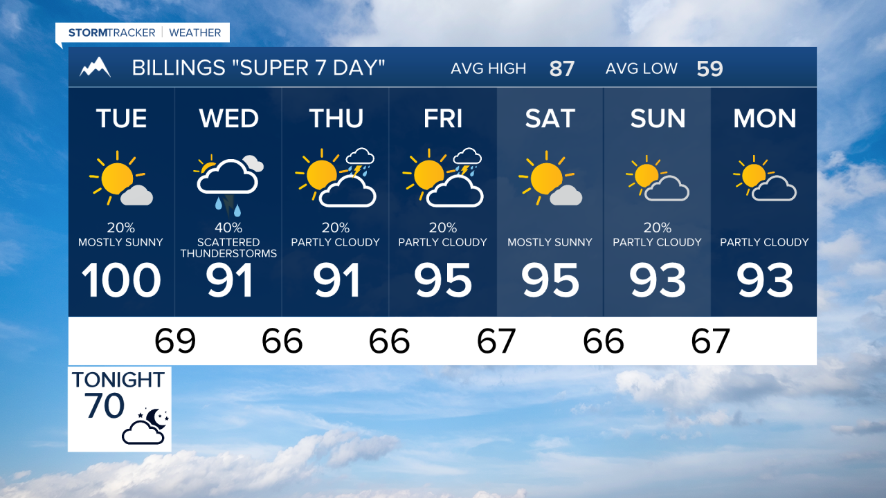

MONTANA — Dangerous heat continues early this week, especially across eastern Montana and northern Wyoming, before a surge of monsoonal moisture brings increasing thunderstorm chances and the potential for heavy rainfall by midweek. While temperatures gradually ease from west to east, humid conditions and localized flash flood concerns may replace the region's recent extreme heat.
MONDAY EVENING
Extreme Heat Warnings remain in effect across much of the region. A weak front has provided some relief, but dangerous heat persists. Meanwhile, increasing monsoonal moisture may trigger a few isolated high-based thunderstorms over the Beartooth Mountains and nearby western locations late in the day and into the evening. Any storms could produce gusty winds and brief, spotty rainfall.
TUESDAY
The upper-level ridge slowly shifts east, allowing temperatures to trend downward across western areas while much of southeast Montana remains very hot. Extreme Heat Warnings continue through the day, including around Billings, with highs still approaching or exceeding 100 degrees in eastern locations. Monsoonal moisture continues to deepen across the region, bringing a growing chance of showers and thunderstorms, especially across central and western sections.
WEDNESDAY
Heat remains most intense across far eastern Montana and Sheridan County, Wyoming, where highs of 100 to 105 degrees and unusually warm overnight temperatures may persist. Extreme Heat Warnings continue for portions of far southeast Montana through the day. At the same time, a much more humid air mass settles over the region with dewpoints rising into the upper 50s and lower 60s. Scattered thunderstorms become more widespread, and some storms may produce very heavy rainfall.
THURSDAY
Monsoonal moisture remains firmly in place, supporting daily chances for showers and thunderstorms. Weak disturbances moving through the southwest flow aloft may enhance storm coverage, particularly over western and central Montana. Localized heavy rainfall becomes a primary concern, with some areas potentially experiencing excessive runoff or flash flooding if storms repeatedly track over the same locations.
FRIDAY
Temperatures remain above normal but noticeably lower than the extreme heat experienced earlier in the week. Thunderstorm chances continue region-wide as abundant moisture lingers. Some storms may again produce torrential downpours, especially where atmospheric moisture remains well above normal.
SATURDAY
A warm and increasingly humid summer pattern continues. Periodic showers and thunderstorms remain possible, with locally heavy rainfall the main impact. Outdoor activities may be disrupted by slow-moving storms capable of producing intense rainfall over short periods.
SUNDAY
The unsettled pattern persists into the end of the weekend. While widespread severe weather is not currently expected, scattered thunderstorms and pockets of heavy rain remain possible. Residents should continue monitoring forecasts as localized flooding concerns may develop wherever the heaviest storms occur.
