

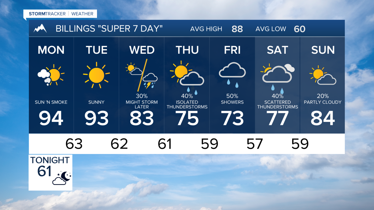

BILLINGS — Wildfire smoke will remain the main weather story for the first half of this week, with hazy skies and occasional air quality concerns across south central and southeast Montana and northern Wyoming. Thunderstorm chances then increase significantly late week as cooler, wetter weather arrives.
SUNDAY NIGHT
Mostly clear to partly cloudy with widespread haze from wildfire smoke. A stray thunderstorm remains possible near the Dakotas border early this evening, mainly east of Baker. Overnight lows settle into the upper 50s and 60s.
MONDAY
Hot and dry conditions continue across Billings, Livingston, Red Lodge, Sheridan, Miles City, Cody, and surrounding areas. Highs climb into the upper 80s to mid 90s under hazy skies. Breezy northwest to north winds and low humidity will maintain elevated fire weather concerns. Most locations remain dry, though an isolated late-day thunderstorm cannot be ruled out near the far eastern Montana border.
TUESDAY
Another warm day with highs generally in the upper 80s to mid 90s. Smoke continues to filter sunshine and keep skies hazy. A few isolated thunderstorms may develop across southeast Montana during the afternoon and evening, especially near the Dakota border, but many areas will remain rain-free.
WEDNESDAY
Moisture begins increasing across the region while temperatures trend slightly cooler, with highs mainly in the 80s. Scattered showers and thunderstorms become more common from southeast Montana into northern Wyoming by afternoon and evening. Some storms may produce brief heavy rain, lightning, and gusty winds.
THURSDAY
A noticeable pattern change arrives as cooler air and increased moisture spread across the area. High temperatures fall into the 70s and lower 80s. Showers and thunderstorms become more widespread across south central Montana, southeast Montana, and northern Wyoming. Locally heavy rainfall is possible with stronger storms.
FRIDAY
Unsettled weather continues. Periods of showers and thunderstorms remain likely, with abundant moisture supporting wetting rains in many locations. Temperatures stay below seasonal averages, generally in the 70s to lower 80s.
SATURDAY
Cooler-than-normal conditions persist. Scattered showers and thunderstorms remain in the forecast, especially during the afternoon and evening. Any storms could produce locally heavy rain and gusty winds.
SUNDAY
The active weather pattern continues into next weekend with additional chances for showers and thunderstorms. Temperatures remain pleasant, generally in the 70s to lower 80s, while smoky conditions may fluctuate depending on rainfall and regional fire activity.
