

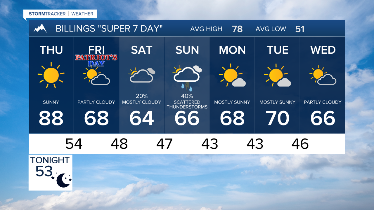

BILLINGS — Fire danger remains the top concern through Thursday across Billings and much of south central and southeast Montana, with warm temperatures, very low humidity, and gusty winds. A major pattern change arrives late this week, bringing cooler weather, widespread rain chances, mountain snow, and even the possibility of the first frost of the season by Monday morning.
TONIGHT
Warm, dry, and breezy conditions continue across Billings, southeast Montana, and northern Wyoming. Elevated fire danger remains in place as low humidity and gusty winds persist. Anyone spending time outdoors should use extra caution with anything that could spark a fire.
THURSDAY
Thursday looks to be the warmest, driest, and windiest day of the stretch. High temperatures will climb well into the 80s, with a few locations approaching 90 degrees. Relative humidity will drop into the low teens while wind gusts increase, especially west of Billings along the foothills and across far southeast Montana. Critical fire weather conditions are expected in several areas, and any fire could spread rapidly.
FRIDAY
A cold front moves through late Thursday night into Friday, shifting winds out of the northeast and beginning a significant cooling trend. High temperatures will fall back into the upper 60s and 70s. Spotty showers and a few weak thunderstorms may develop during the day, especially in the mountains and nearby foothills.
SATURDAY
The cooler pattern settles in as a larger weather system approaches the region. Temperatures continue to trend downward, and scattered showers become more common. The greatest chances for precipitation will be west and north of Billings, although periods of rain are possible throughout south central and southeast Montana.
SUNDAY
Sunday appears to be the wettest day of the forecast. Widespread showers are expected across much of the region, with some areas west and north of Billings potentially receiving a half inch of precipitation or more. The higher mountains will turn much colder, with snow levels dropping through the day and accumulating snow possible on the tallest peaks by Sunday night.
MONDAY
The storm system gradually exits the area, but chilly morning temperatures may lead to the first widespread frost concerns of the season. Foothill communities have a moderate chance of seeing temperatures fall into the mid-30s, with patchy frost possible. Some of the colder foothill locations could even briefly touch freezing. Any lingering showers end as skies slowly clear.
TUESDAY
Drier weather returns across Billings and the surrounding region. Temperatures begin to recover, climbing back into the 70s during the afternoon. While still cooler than earlier in the week, conditions will be much more seasonable as the region settles into a quieter weather pattern.
