

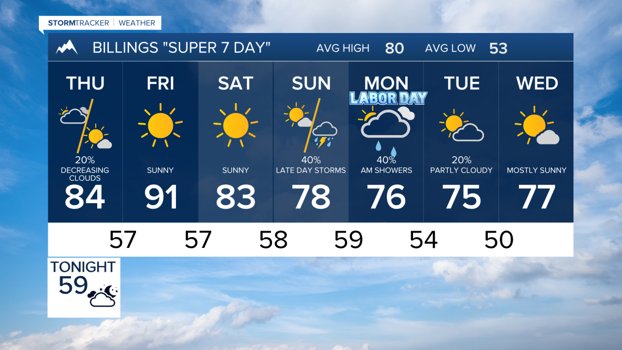

BILLINGS — A few thunderstorms Wednesday evening could become severe east of Billings, while elevated fire weather concerns persist through the end of the workweek. Cooler temperatures and increasing chances for rain arrive this weekend and may continue into next week.
WEDNESDAY
While evening storms will produce brief downpours and gusty winds, a few stronger storms are possible east of Billings toward Miles City and Baker, where large hail and damaging wind gusts could develop.
THURSDAY
Temperatures remain warm, reaching the upper 70s to low 90s. Humidity levels will stay low across much of the region. Winds will not be quite as strong as Wednesday in many locations, but enough breeze combined with dry conditions could bring locally critical fire weather concerns across south central Montana, including areas near Livingston and surrounding foothills. Billings and much of the plains remain warm and dry.
FRIDAY
Heat builds again with highs climbing into the 90s in parts of southeast Montana and northern Wyoming. Breezy conditions are expected to develop, particularly east of Billings, as low pressure strengthens near the Yellowstone Valley. Combined with low humidity, elevated fire weather concerns are likely across southern and eastern sections of the region. A few isolated showers or thunderstorms may develop west of Billings, but most locations stay dry.
SATURDAY
Forecast confidence decreases somewhat, but weather conditions appear to trend more active. Increasing southwest flow aloft may bring scattered showers and thunderstorms to areas west of Billings, including the foothills and mountains. Temperatures begin a gradual cooling trend, while breezy periods continue at times across the region.
SUNDAY
A broader cooling trend settles into south central and southeast Montana and northern Wyoming. More locations could see scattered showers and thunderstorms as a slow-moving upper-level system edges closer. High temperatures trend lower than previous days, providing some relief from the late-summer heat.
MONDAY
Cooler and potentially wetter weather becomes more likely across the region. Periods of showers may develop from the mountains into the plains as the upper-level trough moves east. Temperatures fall closer to seasonal averages, and cloud cover becomes more widespread.
TUESDAY
Unsettled conditions may continue with opportunities for showers and cooler temperatures across the Yellowstone Valley, southeast Montana, and northern Wyoming. While details remain uncertain, confidence is increasing that the hotter, drier pattern will give way to a more autumn-like feel as we move deeper into next week.
