

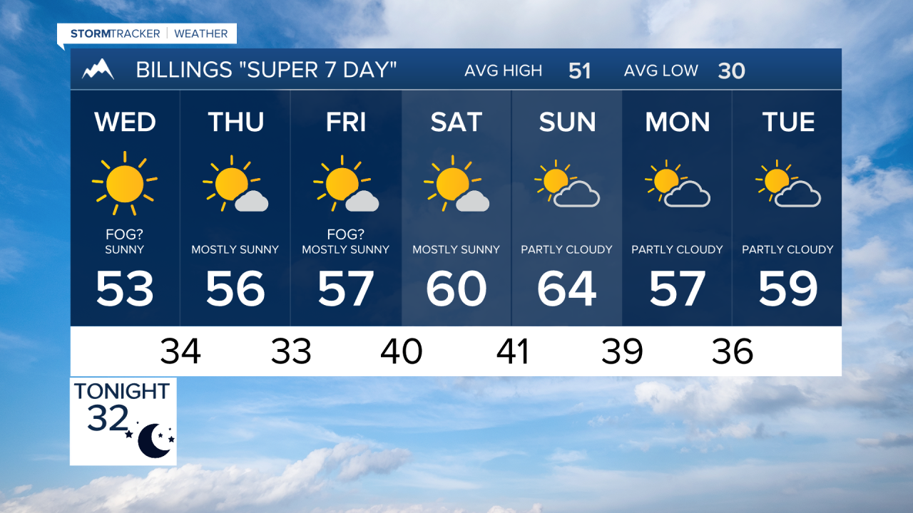

BILLINGS — A much quieter stretch of weather is settling into the region, with mild November temperatures and very little precipitation expected through early next week. The main weather story will shift from areas of morning fog to increasing foothill winds blowing down the last of the leaves beginning Thursday, with Friday and Saturday currently looking like the windiest days.
TUESDAY NIGHT INTO WEDNESDAY
Another round of fog will be possible late tonight into Wednesday morning, mainly across lower elevations east of the foothills. Otherwise, high pressure will keep the region dry. Wednesday afternoon will remain seasonably mild, with highs generally in the upper 40s to middle 50s.
THURSDAY
Temperatures begin another gradual climb, with widespread 50s and some upper 50s across northern Wyoming. Winds will begin increasing along the south-central Montana foothills west of Billings. Thursday appears to be the beginning of a several-day stretch of stronger winds, although the more significant wind potential holds off until Friday.
FRIDAY
Wind becomes the primary weather concern, especially around Livingston and the foothills west of Billings. The setup becomes increasingly favorable for strong wind gusts, although the probability of gusts exceeding 50 mph currently remains below 50 percent. Most communities stay dry, with only a very small chance of precipitation as a disturbance passes near the Canadian border. Highs remain mainly in the 50s.
SATURDAY
Breezy to windy conditions continue along the foothills, with Saturday remaining one of the more favorable days for stronger gusts. Elsewhere, conditions stay mostly dry and mild. Highs should be primarily in the 50s, including the middle to upper 50s around Billings, Hardin and Sheridan.
SUNDAY
Temperatures turn noticeably warmer as upper-level ridging strengthens. Highs climb into the upper 50s and 60s, with Billings around the lower 60s, Hardin in the lower 60s and Sheridan potentially reaching the middle 60s. Foothill winds could remain elevated, but precipitation is not expected.
MONDAY
The mild and mostly dry pattern continues. Highs generally remain in the upper 50s to lower 60s, with Sheridan around the lower 60s. Periods of stronger foothill winds will remain possible as the overall pattern continues to favor downsloping west to southwest flow.
BOTTOM LINE: The next seven days look remarkably dry. After the fog threat through Wednesday morning, attention turns to stronger foothill winds Thursday through the weekend, particularly Friday and Saturday. Temperatures trend warmer as well, with widespread 50s eventually giving way to lower and middle 60s in some areas Sunday and Monday.
