

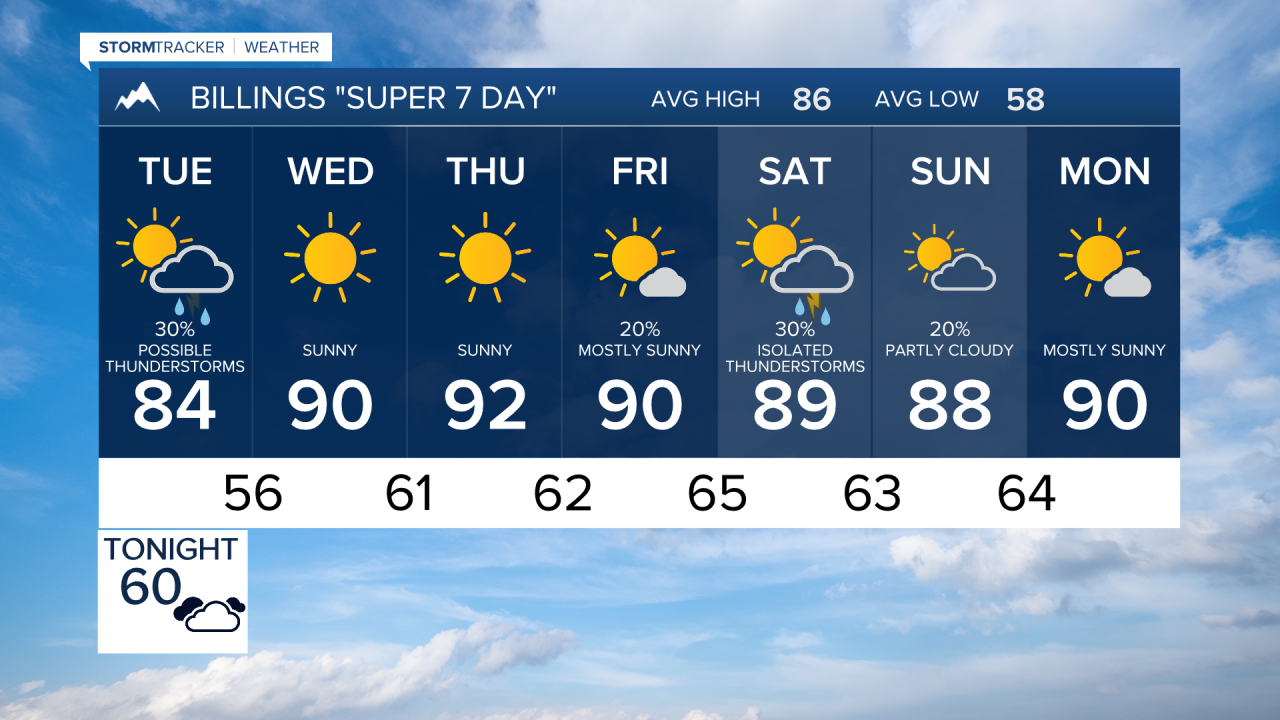

BILLINGS — A stretch of active weather kicks off the forecast before late-week heat and a return to monsoon moisture increase thunderstorm chances heading into the weekend across Billings, south central and southeast Montana, and northern Wyoming.
MONDAY NIGHT
Scattered showers and thunderstorms will continue through the evening across much of southeast Montana and northern Wyoming before diminishing around midnight. A few stronger storms may produce wind gusts over 60 mph, especially east of Billings toward Miles City and the Powder River Basin. Overnight lows will settle into the 50s and lower 60s.
TUESDAY
Another round of scattered afternoon and evening showers and thunderstorms is expected across the region. Storm coverage may be more widespread than Monday, with activity developing during the afternoon and lingering through the night. Temperatures will be slightly cooler, with highs generally in the lower to middle 80s. Outdoor plans should keep an eye on changing weather conditions through the evening.
WEDNESDAY
Drier weather returns as high pressure begins strengthening over the Northern Rockies. Any lingering early morning showers will end, giving way to a mostly sunny sky. Highs will climb back into the 80s across Billings, Livingston, Sheridan, Miles City, and surrounding communities.
THURSDAY
A warm, dry and pleasant late-summer day is expected with sunshine. Afternoon temperatures will rise into the upper 80s to lower 90s across much of south central and southeast Montana and northern Wyoming.
FRIDAY
Heat builds further as the ridge strengthens, with many lower elevation locations reaching the lower 90s. At the same time, moisture begins increasing from the southwest, bringing a gradual return of isolated afternoon and evening thunderstorms.
SATURDAY
A developing monsoon pattern increases the chance for scattered showers and thunderstorms across the region. Temperatures remain warm, generally in the lower 90s, but cloud cover and storms may provide relief from the heat.
SUNDAY
Thunderstorm chances continue as deeper moisture remains in place. While warm temperatures persist, precipitation coverage is expected to be higher than earlier in the week, offering a better opportunity for rainfall.
NEXT MONDAY
The upper ridge begins to weaken slightly, trimming temperatures back a few degrees while maintaining a chance of showers and thunderstorms. Overall, temperatures are expected to remain near or above seasonal averages.
