

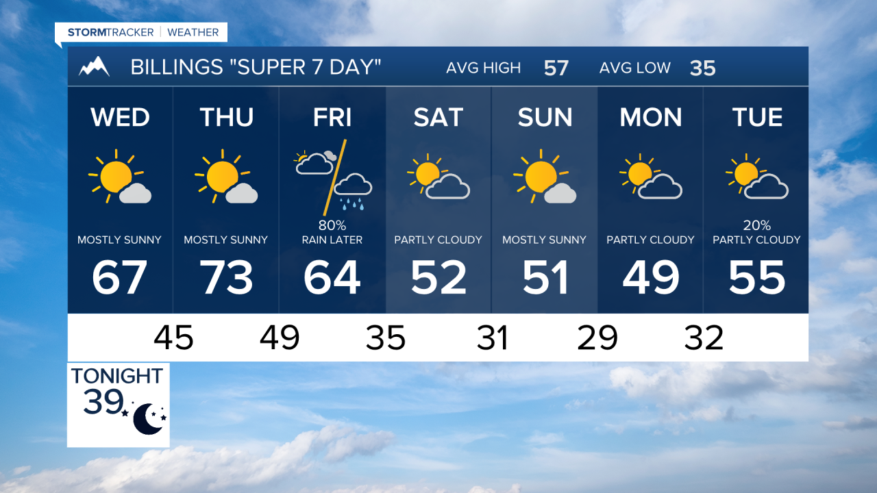

BILINGS — A major late-week change is taking shape for south-central and southeast Montana and northern Wyoming. Warm, sunny weather through Thursday will give way to a much colder, windy and wet Friday, with mountain snow before conditions improve Saturday.
TUESDAY NIGHT:
Quiet and dry tonight. Winds will diminish this evening, setting the stage for a mild and pleasant midweek stretch.
WEDNESDAY:
Plenty of sunshine with light winds and temperatures warming into the 60s to lower 70s. Billings is forecast near 67°, with lower 70s around Livingston, Hardin and Sheridan.
THURSDAY:
The warmest day of the week. Sunshine continues with widespread highs in the mid to upper 70s. Billings is forecast around 73°, while parts of southeast Montana could approach 80°. Southwest flow will begin increasing ahead of an approaching storm system.
THURSDAY NIGHT:
Changes begin first across the western mountains and foothills as a storm system moves into the region. Moisture and colder air will increase as the system approaches south-central Montana.
FRIDAY:
A sharp change to colder, wet and windy weather. Strong northerly winds will push colder air southward with widespread chances for precipitation. Rainfall potential is greatest from Big Horn County, Montana westward into the mountains and foothills around Livingston, while amounts should decrease farther east. Wind gusts over 40 mph are possible across many locations Friday afternoon and evening.
Snow levels will fall from around 10,000 feet Friday morning to 5,000–6,000 feet by midnight. The most impactful snowfall is currently expected above 5,000 feet, with higher elevations of the Beartooth, Absaroka and Crazy Mountains potentially receiving up to 8 inches. The Bighorn Mountains above 7,000 feet are currently forecast for around 2–4 inches. Friday night football could be cold, windy and wet.
SATURDAY:
Rain and mountain snow taper from west to east during the morning, with snow levels potentially dropping to 4,000–5,000 feet before precipitation ends. Conditions improve considerably Saturday afternoon with sunshine developing. Highs will generally be in the upper 40s to mid-50s.
SUNDAY & MONDAY:
Mainly dry and seasonably cool weather settles in. Afternoon temperatures generally remain in the 50s, while overnight lows hover near freezing.
