


BILLINGS — We are entering a very robust weather pattern, with strong winds on Thursday, followed by a chance for heavy, wet snow through Saturday night.
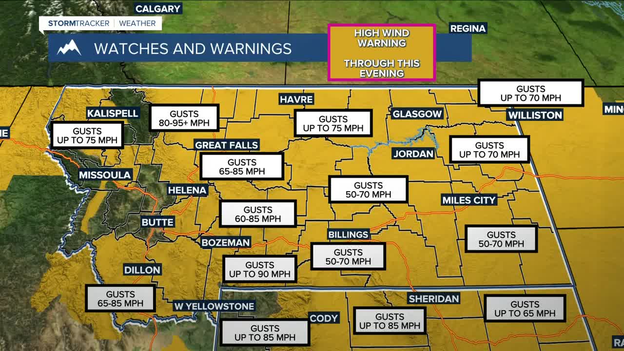
High Wind Warnings are in effect for the area through Thursday evening as potentially damaging winds move through. Possible gusts:
- West 50 to 70 mph for portions of central, south-central, and southeast Montana
- Southwest to west gusts of 60 to 80 mph expected for the Beartooth Foothills and Livingston area
- West wind 60 to 85 mph expected for portions of central and south-central Montana
- Southwest to west 50 to 65 mph expected in northern Park and Paradise Valley
- Southwest to west up to 90 mph expected in the Absaroka/Beartooth Mountains and Crazy Mountains
- West 50 to 70 mph possible in the Red Lodge Foothills and Sheridan Foothills
- Southwest to west gusts to 75 mph expected in the Pryor/Northern Bighorn Mountains in MT and Northeast Bighorn Mountains in WY
- West up to 70 mph expected for a portion of northeast Montana
Impacts may include damage to roofs, fences, and trees, with the potential for power outages. Use caution while commuting throughout the day. Consider delaying travel if you drive a high-profile vehicle, such as a big rig, box truck, etc. Grass fires will also be a concern, so please avoid activities that could cause sparks! A cold front will help ease the winds as the evening progresses.
After the winds die down, our next weather story will be the potential for winter storm conditions through Saturday night into early Sunday. An atmospheric river will pump ample moisture into the area, bringing a prolonged period of snow. Winter Storm Warnings, Watches, and Advisories will be in effect for much of the region during this period. Roads, particularly bridges and overpasses, are likely to become slick and dangerous. Travel may be extremely difficult or even impossible.
- 1 to 3 feet will be possible in the Absaroka/Beartooth Mountains, greatest on south and west-facing aspects. Winds could gust as high as 85 mph on Thursday. The Crazy Mountains could also receive 1-3 feet of snowfall, with gusts as high as 90 mph on Thursday.
- 10 to 20 inches will be possible in the Pryor/Northern Bighorn Mountains in MT and Northeast Bighorn Mountains in WY. Winds could gust as high as 35 mph.
- 7 to 14 inches will be possible in Billings, as well as portions of central, south-central, and southeast Montana, and north-central Wyoming. Winds could gust as high as 50 mph.
- 7 to 14 inches will be possible in northern Rosebud. Winds could gust as high as 30 mph.
- 6 to 12 inches will be possible in Petroleum County, Northern and Southern Rosebud, Powder River, and the Sheridan Foothills
- 5-10 inches will be possible in the Beartooth and Red Lodge Foothills
- 2-6 inches will be possible in Garfield County
Here is a more detailed look at possible snow accumulations:
Alzada, MT: 3–7" (up to 8")
Baker, MT: 2–6" (up to 8")
Big Timber, MT: 1–5" (up to 13")
Billings, MT: 3–8" (up to 13")
Broadus, MT: 2–5" (up to 10")
Burgess Junction, WY: 7–20" (up to 24")
Clearmont, WY: 2–6" (up to 9")
Columbus, MT: 4–6" (up to 15")
Cooke City, MT: 7–33" (up to 40")
Crow Agency, MT: 4–8" (up to 14")
Daisy Pass, MT: 9–36" (up to 43")
Dayton, WY: 3–8" (up to 13")
Ekalaka, MT: 2–7" (up to 9")
Forsyth, MT: 2–8" (up to 11")
Gardiner, MT: Trace–1" (up to 5")
Harlowton, MT: 3–16" (up to 20")
Hysham, MT: 2–10" (up to 12")
Lame Deer, MT: 4–9" (up to 18")
Livingston, MT: 1–2" (up to 9")
Lodge Grass, MT: 4–9" (up to 16")
Miles City, MT: 1–6" (up to 8")
Ranchester, WY: 3–7" (up to 13")
Red Lodge, MT: 5–8" (up to 15")
Roundup, MT: 5–14" (up to 17")
Sheridan, WY: 2–7" (up to 11")
Story, WY: 3–9" (up to 13")
This will be heavy, wet snow, and it could fall steadily through the warning and watch periods. Between 0.50 and 1.50 inches of total moisture could fall, which is much needed as we head into the spring and summer months when wildfire concerns will be high.
Another 1 to 3 inches of snow could fall on Sunday into Monday, impacting the Monday morning commute.
The cold front will also cool daytime highs down into the 20s and 30s (maybe warmer in some locations) across the weekend, before warming back into the 60s and lower 70s by the middle of next week. The snow is expected to melt quickly, but no flooding issues are anticipated.
Miller Robson
Q2 Morning Meteorologist
miller.robson@ktvq.com
