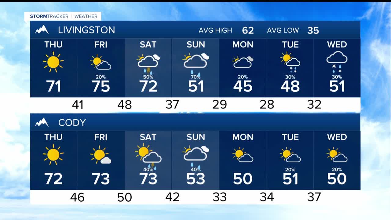


BILLINGS — Residents across Montana and northern Wyoming can expect pleasant fall weather to continue through Friday as high pressure maintains its grip over the region. Warm and dry conditions will dominate, with afternoon temperatures climbing into the upper 60s and 70s while overnight lows settle into the 30s to lower 50s.
There may be a few showers by Friday, primarily in mountain areas where a slight possibility of showers. Most communities will stay completely dry.
Winds will begin to pick up across eastern Montana, where southeasterly gusts in the 20s and 30s mph will become common during the day. By Friday night, breezy conditions will also develop over the foothills west of Billings.
Saturday promises to be another warm day with high temperatures soaring into the 70s and lower 80s across the plains. While eastern Montana should remain dry through the daylight hours, weather conditions will begin to change across south-central Montana and northern Wyoming as the next weather system approaches.
Precipitation chances will increase substantially in these areas, ranging from 20 to 70 percent with the highest probabilities over mountainous terrain. The atmospheric setup could even support a few weak thunderstorms, though the chance remains relatively low.
Expect a dramatic turn Saturday night into Sunday as a cold front sweeps through the region. Significantly cooler temperatures, stronger winds, and widespread precipitation with snow developing over high country areas. The highest chances for meaningful rainfall will occur over south-central Montana and northern Wyoming, while areas near the Montana-Dakota border will see lower but still significant precipitation probabilities.
The system appears capable of producing substantial rainfall amounts, with a 40 to 70 percent chance of seeing a half inch or more of precipitation over south-central Montana and northern Wyoming, dropping to 10 to 30 percent over southeastern Montana.
Snow will become a significant factor for mountain communities as snow levels drop to around 6,000 feet by Sunday. The Absaroka-Beartooth and Crazy Mountains face a 40 to 70 percent chance of receiving six or more inches of snow above 8,000 feet elevation.
By Monday morning, the coldest air mass associated with this system will settle over the region, potentially dropping snow levels to around 4,000 feet in some areas. Melville to Harlowton could experience light snow Monday morning as upslope flow continues even after the main system moves through.
Wind will become notable late Saturday through Sunday as the frontal boundary passes. Gusts in the 20s and 30s mph will be common regionwide, with the strongest winds occurring over the foothills west of Billings and across far eastern Montana. Baker and Ekalaka could see gusts approaching 40 mph.
The temperature contrast will be striking as high temperatures plummet from the 70s and 80s Saturday to the upper 40s and lower 60s Sunday and into early next week. Overnight lows will also turn notably cooler, dropping into the 20s and 30s by Sunday night.
Looking ahead to mid-week, another weather system may impact the region, though significant uncertainty remains in the forecast details. The overall pattern suggests the cooler and wetter weather trend will likely continue, marking a clear transition from the warm, dry conditions that characterized the beginning of the forecast period.
