


BILLINGS — Thursday will be warm, with daytime highs in the mid-70s west to low-80s east. It will start off mostly dry before a Pacific trough brings a decent chance of rain to the western mountains by late in the day. This is expected to spread to the western counties by Friday morning.
An increased chance of rain kicks in by late Friday and is forecast to last into early next week. It will also become much cooler as energy dropping down from Canada introduces colder air into the area.
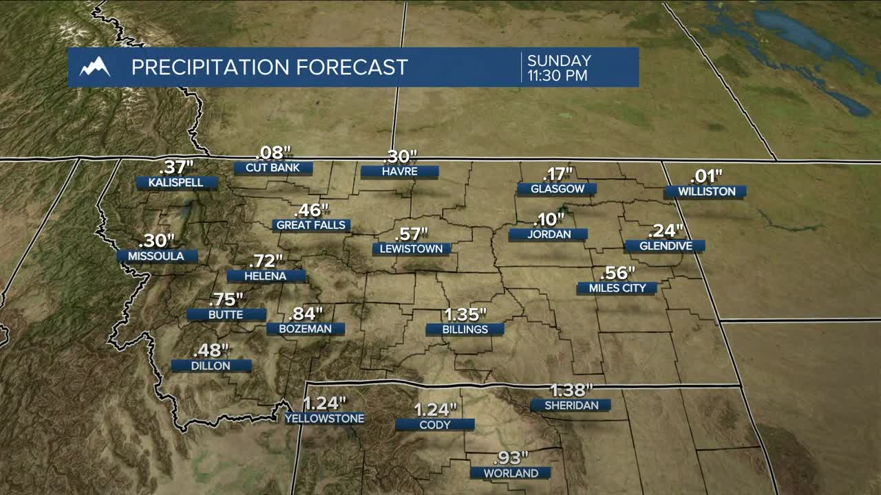
Confidence is growing that this system will bring at least a half inch of rain to much of the area by Sunday evening. Areas along a line south of Livingston to Billings to Ekalaka could pick up over one inch.
Snowfall amounts over the mountains and foothills this weekend will depend on snow levels. Levels could drop to about 10,000 feet on Saturday, then to 6,000 feet by Sunday morning, bringing a greater chance of snow to the foothills. Models are confident of at least 6 inches of snow above 7,500 feet Saturday through Sunday. US-212 Beartooth Highway will be CLOSED Friday starting at noon due to forecasted winter weather. Maintenance crews will assess conditions the week of October 6 and determine whether the road will reopen. The highway will be CLOSED at Vista Point through Wyoming. Be sure to stay updated if you have plans in the mountains or foothills this weekend.
Daytime highs will be in the mid-60s west to low-80s east on Friday, mid-50s west to mid-60s east on Saturday, mid-40s west to mid-50s east on Sunday, mainly in the mid-50s on Monday, then low to mid-60s on Tuesday.
Nighttime lows will be mainly in the 40s and 50s through Friday night, cooling to the 30s and 40s Saturday night, then dipping to the 20s and 30s Sunday and Monday nights. Many areas could see their first frost of the season during those nights, while river valleys could see a freeze.
Miller Robson
Q2 Morning Meteorologist
miller.robson@ktvq.com
