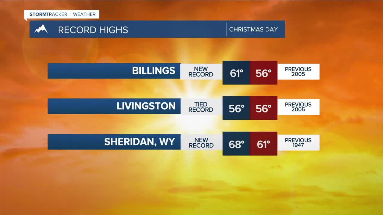


BILLINGS — Warm temperatures continue Friday thanks to persistent downslope flow. While still unseasonably mild, the air mass won’t be quite as warm as Thursday. Highs will reach the 50s to near 60°F, though record highs for December 26 remain a bit higher and will be tough to break.
Moist southwest flow stays locked in across the region, keeping periods of accumulating mountain snow going through Saturday—especially on southwest- and west-facing slopes of the Beartooth and Absaroka ranges. Another 10–18 inches of snow is likely, increasing avalanche concerns around Cooke City. Lower elevations remain mostly dry Friday night, with only a slight chance of a brief, insignificant shower.
Ahead of Saturday’s approaching system, winds will increase across the foothills and adjacent plains. Pressure gradients over the Paradise Valley and foothills will tighten and could produce gusts over 50 mph at gap locations like Livingston and Nye, and gusts of 35–45 mph along the US-191 corridor from Big Timber through Harlowton today through Saturday morning.
A sharp Canadian cold front arrives Saturday, dropping temperatures during the day. This is not a high-impact system, but snowfall totals of 1–3 inches are possible along the southern foothills. Rapidly falling temperatures could cause roads to transition from wet to icy Saturday afternoon and evening, including parts of Billings, with higher confidence in areas like Red Lodge and Sheridan. This will be something to monitor for weekend travel.
Much colder air settles in Saturday night into Sunday, with brisk northwest winds behind the front. Sub-zero wind chills are likely east of Rosebud County late Saturday night into Sunday morning. Highs on Sunday range from the upper 20s in the west to single digits near the Montana–Dakota border.
A warming trend begins Monday as high pressure builds in, pushing daytime highs back into the 40s to lower 50s early next week, before another potential cold front could drop highs into the 30s during the second half of next week.
Miller Robson
Q2 Morning Meteorologist
miller.robson@ktvq.com
