


BILLINGS — Rain and melting snow during the overnight hours have caused wet roads in many locations. Patchy black ice is possible for the morning commute in areas where temperatures have dipped below freezing—especially on bridges. Sidewalks will be slick, too. Winter Weather Advisories remain in effect across the western foothills and nearby areas for the threat of freezing rain and mixed precipitation. Temperatures rise into the 40s later today, which should help reduce the risk of icy roads by late morning or afternoon.
West to southwest flow continues across the region, keeping Pacific moisture streaming into the area. Snow continues in the mountains, and Winter Storm Warnings remain in effect for the Beartooth and Crazy Mountains through 5 PM Monday. A weak disturbance moving across northern zones could produce bands of light mixed precipitation from Park County east toward Custer and Fallon counties. Some areas—especially river valleys—could briefly see light freezing rain or drizzle.
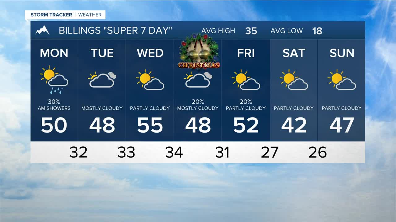
Looking ahead, upper-level ridging remains anchored over the central U.S., keeping west to southwest flow dominant through the week. This pattern favors periodic surges of Pacific moisture and continued orographic snow in the Absaroka and Beartooth Mountains. No major wind events are expected, though localized gap winds are possible Tuesday night into Wednesday, and stronger winds may develop along the western foothills on Friday. Temperatures stay above normal, with highs commonly in the 40s to mid-50s.
A cold front may move through late Wednesday night into Thursday, followed by a series of weak clipper-type systems late week into the weekend, bringing slightly cooler air. The best chance for any widespread precipitation appears to be Christmas Day, when the front could bring scattered rain and snow. Any accumulating snowfall at this point looks limited to the mountains, generally in the 2–4 inch range.
Miller Robson
Q2 Morning Meteorologist
miller.robson@ktvq.com
