


BILLINGS — It’s a foggy start this morning, roughly from Roundup to Billings to Sheridan, WY, and areas east, where visibility could dip below half a mile and roads could be slick — especially on bridges and overpasses.
Thanksgiving Day is essentially the calm before the storm. We get a quick ridge, quiet weather, and temps similar to the last couple of days — but that changes tonight as the new pattern rolls in.
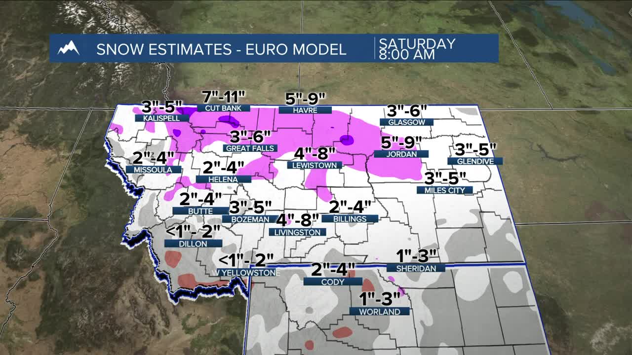
This weekend’s system arrives in two waves. As the upper trough slides into eastern Montana, strong frontal forcing will set up steady snow across southeast Montana. Temperatures look cold enough for all snow from the start. By Friday morning, a second round develops through terrain-driven upslope into south-central Montana. Snow amounts will hinge on wind direction — a true northeast flow would boost totals, while more of a north/northwest flow would limit them. Even without strong large-scale support, the surge of moisture will help smaller pockets of lift easily produce snow. Everything moves out rather quickly by Saturday morning.
Right now, most of south-central Montana looks to land in the 1–6 inch range, with higher totals on north-facing slopes. Southeast Montana could see a bit more — places like Custer County could end up anywhere from 1–7 inches. If you look at a blend of models, generally 2–5 inches is the safer bet.
The bigger story after the snow is the cold. All of southern Montana has at least a low-to-medium chance of dropping below zero. Park and Wheatland counties hit their coldest night Friday night; the rest of the region bottoms out Saturday night. Expect post-Thanksgiving travel impacts.
Next week starts a slow warm-up, with highs back in the upper 30s to low 40s by Wednesday. Breezy gap winds are possible around Livingston late Monday into Tuesday, with another round of precip in the mid-week window.
Miller Robson
Q2 Morning Meteorologist
miller.robson@ktvq.com
