

BILLINGS — It's hard to tell by looking outside Monday afternoon, but there's a big snowstorm in the state right now. For Billings, it looks like the whole storm is just doing an end run around us or just jumping over the city.
The current temperature in Billings is 40 degrees early Monday afternoon with a northwest wind at 35 mph, which gives us a windchill factor that feels like 28 degrees.
Around the rest of the state, our current temps are mostly to the 20s and 30s and Billings is the only one up into the 40s.
The threat board is starting to fill in with Winter Weather Advisories for, in some cases, very heavy snow and gusty winds. Snowfall amounts range anywhere from 3 to 7 inches, all the way up to 8 inches of snow in the southeast corner of the state.
Some of the winds could be gusting up to 60 mph from Big Timber to Harlowton.
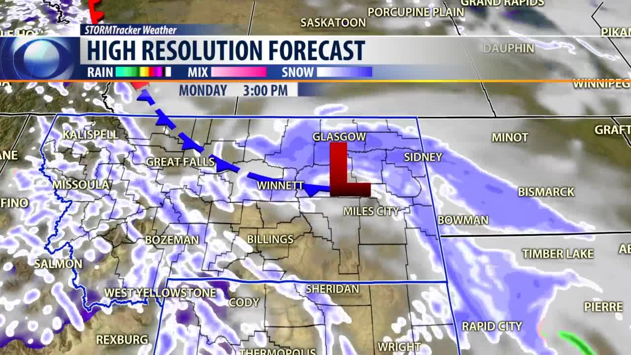
The Doppler radar tells the story. There's a low pressure cell over by Glasgow and Jordan spinning around there and snow from Great Falls all the way down to just west of Billings.
If your travel plans take you there Monday, Montana Highway Patrols says look out for snow-packed roads and icy conditions with multiple slide offs already reported on the roadway.
The high-resolution forecast model shows that low pressure cell over the northeast corner the state and a new cold front developing right behind it.
That low is forecast to drop all the way down into northeastern Wyoming and take the snow with it, but also bring some more cold air down from Canada across most of western Montana and into western Billings later Monday night and Tuesday morning.
Eventually that low will continue to drop all the way down in the central plains and a warm front will sweep across the state on Wednesday afternoon. This will help warm the temperatures back up to where they should be for this time of year.
Additional snowfall amounts are expected to be heavier in eastern Montana, ranging anywhere from another 2 to 4 inches there and 1 to 2 inches in the West.
Temperatures will continue to get into the 30s Monday afternoon hour, then drop back down into the low 20s in the morning and back up into the low 30s Tuesday afternoon.
We will top out at 36 degrees on Tuesday and work our way up to the 40s on Wednesday and Thursday, possibly getting into the 50s just in time for the weekend.
BILLINGS FORECAST
TONIGHT: Mostly cloudy with patchy blowing snow early in the evening and a 40% chance for some snow showers and very windy. Northwest winds 15 to 30 mph gusting to 45 mph in the evening becoming northerly 10 to 20 mph overnight. Low 21 degrees.
TUESDAY: Mostly sunny and cool. West winds 5 to 15 mph. High 36 degrees.
WEDNESDAY: Partly sunny, breezy and warmer. West winds 15 to 25 mph. High 45 degrees.
