

TONIGHT THROUGH WEDNESDAY MORNING: Wet, slushy snow has already stacked up to two inches across northern and southern Big Horn County, and that snow will slowly push south into northern Wyoming and southeast Montana through this evening. The mountains could see 3 to 7 inches before it's all said and done, while the southern foothills pick up 1 to 3 inches.
The evening commute in the Sheridan area and along I-90 will feel it with slick spots are a real concern. Even Powder River and Carter counties in southeast Montana could squeeze out an inch or two. Snow tapers off after midnight, but lingering slick roads will last into Wednesday morning's commute, which is why Winter Weather Advisories stretch to 9 AM Wednesday.
WEDNESDAY: Skies begin to clear and temperatures warm into the upper 40s. By late afternoon and evening, winds start to pick up in the classic gap flow areas like Livingston and Nye as pressure begins tightening on the left side of the Rockies. Gusts of 30 to 40 mph are possible in many areas during the afternoon. By Wednesday night, strong winds begin pushing into the north-central Montana foothills, and the main event is being loaded.
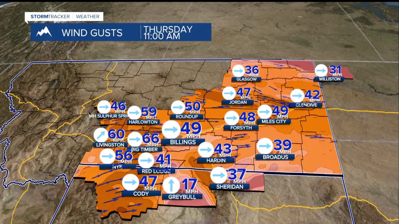
THURSDAY: A powerful jet streak (basically a river of wind high in the atmosphere) roars directly over the region. Winds move out of the foothills and crash into the plains in the early morning hours Thursday.
The current timing would have the Billings area see winds increase starting at around 10 a.m. Gusts of 75 to 90 mph are possible in and near the foothills, with 65 to 80 mph gusts across the plains.
The probability of gusts exceeding 60 mph is essentially 100% in the foothills and drops to about 30% farther east. Damage to rooftops, fences, and trees should be expected, and localized power outages are possible.
By Thursday evening, a cold front sweeps in from the north, shifting winds to the northwest and gradually pulling gusts down to 25 to 35 mph, finally falling below 20 mph by mid-evening.
THURSDAY NIGHT THROUGH FRIDAY: As the front pushes through Thursday evening, scattered rain and snow showers develop and could organize into a snow band that lifts slowly northward through Friday, leaving a few inches of wet snow.
Billings to Columbus on I-90 could see impacts for the Friday morning commute. By later Friday, the heaviest activity pushes toward Miles City and Baker. We should see a wide temperature spread with afternoon highs ranging from the lower 50s west of Billings to the mid-30s to the east.
FRIDAY NIGHT THROUGH THE WEEKEND: Another weak wave in the flow allows cold air to set the stage for an overrunning pattern fed by a powerful stream of Pacific moisture that streams into the region through Saturday before gradually easing Saturday night. The result could be heavy snowfall, particularly north of I-90 and I-94.
Right now, there's a 30 to 60% chance of at least 4 inches of snowfall in those areas, with a 50% chance of 8 or more inches for Wheatland (Harlowton) and Golden Valley (Ryegate) counties. The mountains could see 1 to 3 feet of snow from Wednesday night through Saturday night.
The exact placement of the heaviest snowfall band is highly uncertain and just a little wander will have big impacts on temperatures and rain and snowfall. Weekend highs will be chilly, ranging from the 20s to the 30s.
EARLY NEXT WEEK: As the weekend system winds down, a brief transition period Sunday night through Monday could still generate 1 to 3 additional inches of snow with impacts to the Monday morning commute. Uncertainty is high here.
Look for strong ridging to build toward the middle of next week, potentially pushing temperatures 15 to 25 degrees above normal with highs in the 60s to lower 70s. That kind of warm-up would quickly erase whatever snow the weekend delivers.
